Weather Alerts for California
1. Dust Advisory for: Imperial, CA
2. Extreme Heat Warning for: Western Siskiyou County; Central Siskiyou County
3. Flash Flood Warning for: Imperial, CA
4. Flash Flood Warning for: Imperial, CA
5. Flash Flood Warning for: Imperial, CA
6. Flash Flood Warning for: Riverside, CA
7. Flash Flood Warning for: San Bernardino, CA
8. Flash Flood Warning for: San Diego, CA
9. Flash Flood Warning for: San Diego, CA
10. Flash Flood Warning for: San Diego, CA
11. Flood Advisory for: Fresno, CA
12. Flood Advisory for: Fresno, CA
13. Flood Advisory for: Fresno, CA
14. Flood Advisory for: Imperial, CA
15. Flood Advisory for: Kern, CA
16. Flood Advisory for: Madera, CA; Mariposa, CA
17. Flood Advisory for: Mariposa, CA; Tuolumne, CA
18. Flood Advisory for: Nevada, CA; Placer, CA; Sierra, CA
19. Flood Advisory for: Riverside, CA
20. Flood Advisory for: Riverside, CA
21. Flood Advisory for: San Bernardino, CA
22. Flood Advisory for: San Diego, CA
23. Flood Advisory for: Sierra, CA
24. Flood Watch for: Lassen-Eastern Plumas-Eastern Sierra Counties; Greater Lake Tahoe Area; Mono; Mineral and Southern Lyon Counties; Greater Lake Tahoe Area; Greater Reno-Carson City-Minden Area
25. Flood Watch for: Yosemite NP outside of the valley; Yosemite Valley; San Joaquin River Canyon; Upper San Joaquin River; Kaiser to Rodgers Ridge; Kings Canyon NP; Grant Grove Area; Sequoia NP; South End of the Upper Sierra
26. Red Flag Warning for: Trinity
27. Red Flag Warning for: Western Klamath National Forest; Central Siskiyou County Including Shasta Valley; Shasta-Trinity National Forest in Siskiyou County; Siskiyou County from the Cascade Mountains East and South to Mt Shasta; Modoc County Except for the Surprise Valley; Umpqua National Forest; Western Rogue Basin including the Illinois Valley; Siskiyou Mountains; Eastern Rogue Valley; Southern Oregon Cascades; Klamath Basin and the Fremont-Winema National Forest; South Central Oregon Desert including the BLM Land in Eastern Lake and Western Harney Counties
28. Red Flag Warning for: Western Klamath National Forest; Central Siskiyou County Including Shasta Valley; Shasta-Trinity National Forest in Siskiyou County; Siskiyou County from the Cascade Mountains East and South to Mt Shasta; Modoc County Except for the Surprise Valley; Umpqua National Forest; Western Rogue Basin including the Illinois Valley; Siskiyou Mountains; Eastern Rogue Valley; Southern Oregon Cascades; Klamath Basin and the Fremont-Winema National Forest; South Central Oregon Desert including the BLM Land in Eastern Lake and Western Harney Counties
29. Severe Thunderstorm Warning for: Imperial, CA
30. Severe Thunderstorm Warning for: Riverside, CA
31. Severe Thunderstorm Warning for: San Diego, CA
32. Special Weather Statement for: Apple and Lucerne Valleys
33. Special Weather Statement for: Fresno-Tulare Lower Sierra; Kaiser to Rodgers Ridge; Kings Canyon NP; Grant Grove Area
34. Special Weather Statement for: Northern Trinity
35. Special Weather Statement for: South End of the Upper Sierra; Kern River Valley; Piute Walker Basin; Mojave Desert Slopes
36. Special Weather Statement for: Western Plumas County/Lassen Park
Want more detail? Get the Complete 7 Day and Night Detailed Forecast!
Current U.S. National Radar--Current
The Current National Weather Radar is shown below with a UTC Time (subtract 5 hours from UTC to get Eastern Time).

National Weather Forecast--Current
The Current National Weather Forecast and National Weather Map are shown below.

National Weather Forecast for Tomorrow
Tomorrow National Weather Forecast and Tomorrow National Weather Map are show below.

North America Water Vapor (Moisture)
This map shows recent moisture content over North America. Bright and colored areas show high moisture (ie, clouds); brown indicates very little moisture present; black indicates no moisture.

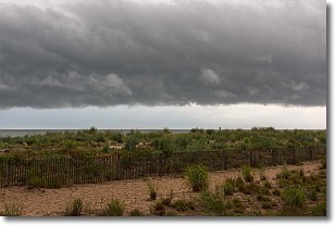
Weather Topic: What are Shelf Clouds?
Home - Education - Cloud Types - Shelf Clouds
 Next Topic: Sleet
A shelf cloud is similar to a wall cloud, but forms at the front
of a storm cloud, instead of at the rear, where wall clouds form.
A shelf cloud is caused by a series of events set into motion by the advancing
storm; first, cool air settles along the ground where precipitation has just fallen.
As the cool air is brought in, the warmer air is displaced, and rises above it,
because it is less dense. When the warmer air reaches the bottom of the storm cloud,
it begins to cool again, and the resulting condensation is a visible shelf cloud.
Next Topic: Sleet
Weather Topic: What is Snow?
Home - Education - Precipitation - Snow
 Next Topic: Stratocumulus Clouds
Snow is precipitation taking the form of ice crystals. Each ice crystal, or snowflake,
has unique characteristics, but all of them grow in a hexagonal structure.
Snowfall can last for sustained periods of time and result in significant buildup
of snow on the ground.
On the earth's surface, snow starts out light and powdery, but as it begins to melt
it tends to become more granular, producing small bits of ice which have the consistency of
sand. After several cycles of melting and freezing, snow can become very dense
and ice-like, commonly known as snow pack.
Next Topic: Stratocumulus Clouds
Current conditions powered by WeatherAPI.com


