Weather Alert in New Mexico
Wind Advisory issued February 18 at 6:33AM MST until February 18 at 8:00PM MST by NWS El Paso Tx/Santa Teresa NM
AREAS AFFECTED: Upper Gila River Valley; Southern Gila Foothills/Mimbres Valley; Eastern Black Range Foothills; Sierra County Lakes; West Slopes Sacramento Mountains Below 7500 Feet; Central Grant County/Silver City Area; East Central Tularosa Basin/Alamogordo
DESCRIPTION: * WHAT...Southwest winds 30 to 40 mph with gusts up to 65 mph expected. * WHERE...East Central Tularosa Basin/Alamogordo, Sierra County Lakes, West Slopes Sacramento Mountains Below 7500 Feet, Central Grant County/Silver City Area, Eastern Black Range Foothills, Southern Gila Foothills/Mimbres Valley, and Upper Gila River Valley. * WHEN...From 11 AM this morning to 8 PM MST this evening. * IMPACTS...Gusty winds will blow around unsecured objects. Tree limbs could be blown down and a few power outages may result.
INSTRUCTION: Winds this strong can make driving difficult, especially for high profile vehicles. Use extra caution.
Want more detail? Get the Complete 7 Day and Night Detailed Forecast!
Current U.S. National Radar--Current
The Current National Weather Radar is shown below with a UTC Time (subtract 5 hours from UTC to get Eastern Time).

National Weather Forecast--Current
The Current National Weather Forecast and National Weather Map are shown below.

National Weather Forecast for Tomorrow
Tomorrow National Weather Forecast and Tomorrow National Weather Map are show below.

North America Water Vapor (Moisture)
This map shows recent moisture content over North America. Bright and colored areas show high moisture (ie, clouds); brown indicates very little moisture present; black indicates no moisture.

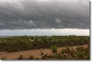
Weather Topic: What are Shelf Clouds?
Home - Education - Cloud Types - Shelf Clouds
 Next Topic: Sleet
A shelf cloud is similar to a wall cloud, but forms at the front
of a storm cloud, instead of at the rear, where wall clouds form.
A shelf cloud is caused by a series of events set into motion by the advancing
storm; first, cool air settles along the ground where precipitation has just fallen.
As the cool air is brought in, the warmer air is displaced, and rises above it,
because it is less dense. When the warmer air reaches the bottom of the storm cloud,
it begins to cool again, and the resulting condensation is a visible shelf cloud.
Next Topic: Sleet
Weather Topic: What is Snow?
Home - Education - Precipitation - Snow
 Next Topic: Stratocumulus Clouds
Snow is precipitation taking the form of ice crystals. Each ice crystal, or snowflake,
has unique characteristics, but all of them grow in a hexagonal structure.
Snowfall can last for sustained periods of time and result in significant buildup
of snow on the ground.
On the earth's surface, snow starts out light and powdery, but as it begins to melt
it tends to become more granular, producing small bits of ice which have the consistency of
sand. After several cycles of melting and freezing, snow can become very dense
and ice-like, commonly known as snow pack.
Next Topic: Stratocumulus Clouds
Current conditions powered by WeatherAPI.com


