Weather Alert in Alaska
High Wind Watch issued February 23 at 3:34PM AKST until February 25 at 9:00PM AKST by NWS Anchorage AK
AREAS AFFECTED: Kodiak Island Northeast
DESCRIPTION: * WHAT...Northwest winds 35 to 50 mph with gusts up to 75 mph possible. Wind chills dropping as low as 15 below zero Wednesday morning. * WHERE...Northeast end of Kodiak Island, including Kodiak City. * WHEN...From late Tuesday night through Wednesday evening. * IMPACTS...High winds could move loose debris, damage property, and cause power outages. Travel could be difficult. Wind chills as low as 15 below zero could result in hypothermia or frostbite if precautions are not taken. * ADDITIONAL DETAILS...The pattern is very similar to last Thursday night when Kodiak City observed high winds, with cold Arctic air surging across Kodiak Island Tuesday night through Wednesday. There is a subtle difference in the upper levels, with a disturbance possible passing just north of the island instead of passing overhead. Thus, winds in this upcoming event could be just a bit weaker than last Thursday night. The strongest winds are expected Wednesday morning.
INSTRUCTION: A high wind watch means there is potential for a hazardous high wind event. Monitor the latest forecasts and warnings for updates on this situation. Fasten loose objects or shelter objects in a safe location prior to the onset of winds.
Want more detail? Get the Complete 7 Day and Night Detailed Forecast!
Current U.S. National Radar--Current
The Current National Weather Radar is shown below with a UTC Time (subtract 5 hours from UTC to get Eastern Time).

National Weather Forecast--Current
The Current National Weather Forecast and National Weather Map are shown below.

National Weather Forecast for Tomorrow
Tomorrow National Weather Forecast and Tomorrow National Weather Map are show below.

North America Water Vapor (Moisture)
This map shows recent moisture content over North America. Bright and colored areas show high moisture (ie, clouds); brown indicates very little moisture present; black indicates no moisture.

Weather Topic: What is Rain?
Home - Education - Precipitation - Rain
 Next Topic: Shelf Clouds
Precipitation in the form of water droplets is called rain.
Rain generally has a tendency to fall with less intensity over a greater period
of time, and when rainfall is more severe it is usually less sustained.
Rain is the most common form of precipitation and happens with greater frequency
depending on the season and regional influences. Cities have been shown to have
an observable effect on rainfall, due to an effect called the urban heat island.
Compared to upwind, monthly rainfall between twenty and forty miles downwind of
cities is 30% greater.
Next Topic: Shelf Clouds
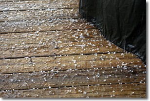
Weather Topic: What is Sleet?
Home - Education - Precipitation - Sleet
 Next Topic: Snow
Sleet is a form of precipitation in which small ice pellets are the primary
components. These ice pellets are smaller and more translucent than hailstones,
and harder than graupel. Sleet is caused by specific atmospheric conditions and
therefore typically doesn't last for extended periods of time.
The condition which leads to sleet formation requires a warmer body of air to be
wedged in between two sub-freezing bodies of air. When snow falls through a warmer
layer of air it melts, and as it falls through the next sub-freezing body of air
it freezes again, forming ice pellets known as sleet. In some cases, water
droplets don't have time to freeze before reaching the surface and the result is
freezing rain.
Next Topic: Snow
Current conditions powered by WeatherAPI.com


