Weather Alert in California
Flood Warning issued February 24 at 7:46PM PST until February 25 at 7:00AM PST by NWS Eureka CA
AREAS AFFECTED: Mendocino, CA
DESCRIPTION: ...The National Weather Service in Eureka has issued a Flood Warning for the following rivers in California... Navarro River at Navarro affecting Mendocino County. For the Navarro River...including Navarro...Minor flooding is forecast. * WHAT...Minor flooding is forecast. * WHERE...Navarro River at Navarro. * WHEN...Until Wednesday morning. * IMPACTS...Starting at 23.0 feet, Flooding of Highway 128 approximately 5 miles east of Highway 1 is certain and the road will be closed. Motorists should use alternate routes. * ADDITIONAL DETAILS... - At 7:15 PM PST Tuesday the stage was 20.5 feet. - Forecast...The river is expected to rise above flood stage late this evening to a crest of 26.5 feet just after midnight tonight. It will then fall below flood stage Wednesday morning. - Flood stage is 23.0 feet. - Flood History...This crest compares to a previous crest of 26.7 feet on 03/24/2011. - http://www.weather.gov/safety/flood
INSTRUCTION: Turn around, don't drown when encountering flooded roads. Most flood deaths occur in vehicles. Motorists should not attempt to drive around barricades or drive cars through flooded areas. Be especially cautious at night when it is harder to recognize the dangers of flooding. Please report observed flooding to local emergency services or law enforcement and request they pass this information to the National Weather Service when you can do so safely. Additional information is available at weather.gov/eka. The next statement will be issued Wednesday morning at 700 AM PST.
Want more detail? Get the Complete 7 Day and Night Detailed Forecast!
Current U.S. National Radar--Current
The Current National Weather Radar is shown below with a UTC Time (subtract 5 hours from UTC to get Eastern Time).

National Weather Forecast--Current
The Current National Weather Forecast and National Weather Map are shown below.

National Weather Forecast for Tomorrow
Tomorrow National Weather Forecast and Tomorrow National Weather Map are show below.

North America Water Vapor (Moisture)
This map shows recent moisture content over North America. Bright and colored areas show high moisture (ie, clouds); brown indicates very little moisture present; black indicates no moisture.

Weather Topic: What is Sleet?
Home - Education - Precipitation - Sleet
 Next Topic: Snow
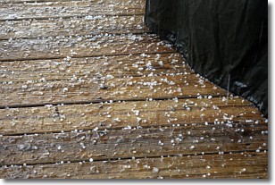
Sleet is a form of precipitation in which small ice pellets are the primary
components. These ice pellets are smaller and more translucent than hailstones,
and harder than graupel. Sleet is caused by specific atmospheric conditions and
therefore typically doesn't last for extended periods of time.
The condition which leads to sleet formation requires a warmer body of air to be
wedged in between two sub-freezing bodies of air. When snow falls through a warmer
layer of air it melts, and as it falls through the next sub-freezing body of air
it freezes again, forming ice pellets known as sleet. In some cases, water
droplets don't have time to freeze before reaching the surface and the result is
freezing rain.
Next Topic: Snow
Weather Topic: What are Stratocumulus Clouds?
Home - Education - Cloud Types - Stratocumulus Clouds
 Next Topic: Stratus Clouds
Stratocumulus clouds are similar to altocumulus clouds in their
fluffy appearance, but have a slightly darker shade due to their additional mass.
A good way to distinguish the two cloud types is to hold your hand out and measure
the size of an individual cloud; if it is the size of your thumb it is generally
an altocumulus cloud, if it is the size of your hand it is generally a
stratocumulus cloud.
It is uncommon for stratocumulus clouds to produce precipitation, but if they do
it is usually a light rain or snow.
Next Topic: Stratus Clouds
Current conditions powered by WeatherAPI.com


