Weather Alert in New York
Flood Watch issued February 21 at 2:42AM EST until February 21 at 8:00PM EST by NWS Binghamton NY
AREAS AFFECTED: Steuben; Tompkins
DESCRIPTION: An ice jam may cause water to infiltrate the lowlands along the river. * WHAT...Flooding caused by an ice jam continues to be possible. * WHERE...A portion of central New York, including the following counties, Steuben and Tompkins. * WHEN...Through this evening. * IMPACTS...The combination of recent rain and snowmelt will result in increased flow along rivers and streams in Tompkins and Steuben counties through Saturday. Ice on the rivers may break up, jam downstream and cause flooding along the river. * ADDITIONAL DETAILS... - For Steuben County, ice jams have been reported by county officials along the Canisteo and Cohocton Rivers. The ice jam on the CanisteoRiver is located near West Cameron. The ice jam on theCohocton River is located near the Route 4 bridge about 2 miles upstream from Coopers Plain. For Tompkins County, ice jams have been reported by county officials along the Fall Creek in Ithaca. The ice jam on Fall Creek is located near Beebe Lake and Cornell University in Ithaca. - https://www.weather.gov/safety/flood
INSTRUCTION: You should monitor later forecasts and be alert for possible Flood Warnings. Those living in areas prone to flooding should be prepared to take action should flooding develop.
Want more detail? Get the Complete 7 Day and Night Detailed Forecast!
Current U.S. National Radar--Current
The Current National Weather Radar is shown below with a UTC Time (subtract 5 hours from UTC to get Eastern Time).

National Weather Forecast--Current
The Current National Weather Forecast and National Weather Map are shown below.

National Weather Forecast for Tomorrow
Tomorrow National Weather Forecast and Tomorrow National Weather Map are show below.

North America Water Vapor (Moisture)
This map shows recent moisture content over North America. Bright and colored areas show high moisture (ie, clouds); brown indicates very little moisture present; black indicates no moisture.

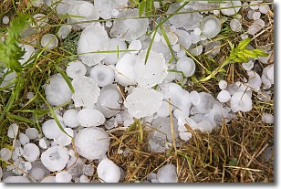
Weather Topic: What is Hail?
Home - Education - Precipitation - Hail
 Next Topic: Hole Punch Clouds
Hail is a form of precipitation which is recognized by large solid balls or
clumps of ice. Hail is created by thunderstorm clouds with strong updrafts of wind.
As the hailstones remain in the updraft, ice is deposited onto them until their
weight becomes heavy enough for them to fall to the earth's surface.
Hail storms can cause significant damage to crops, aircrafts, and man-made structures,
despite the fact that the duration is usually less than ten minutes.
Next Topic: Hole Punch Clouds
Weather Topic: What are Mammatus Clouds?
Home - Education - Cloud Types - Mammatus Clouds
 Next Topic: Nimbostratus Clouds
A mammatus cloud is a cloud with a unique feature which resembles
a web of pouches hanging along the base of the cloud.
In the United States, mammatus clouds tend to form in the warmer months, commonly
in the Midwest and eastern regions.
While they usually form at the bottom of a cumulonimbis cloud, they can also form
under altostratus, altocumulus, stratocumulus, and cirrus clouds. Mammatus clouds
warn that severe weather is close.
Next Topic: Nimbostratus Clouds
Current conditions powered by WeatherAPI.com


