Weather Alert in California
Red Flag Warning issued July 27 at 1:06PM PDT until July 27 at 11:00PM PDT by NWS Medford OR
AREAS AFFECTED: Western Klamath National Forest; Central Siskiyou County Including Shasta Valley
DESCRIPTION: * IMPACTS...Abundant lightning on dry fuels resulting in the potential for numerous new fire starts. * AFFECTED AREA...In California...the eastern portion of Fire weather zone 280, including the Scott Valley and areas eastward to include all of Fire Weather zone 281. * THUNDERSTORMS...Scattered thunderstorms with abundant lightning. Storms are likely to be wet, but lightning strikes outside of precipitation cores are possible, and cause for concern for new fire starts. * OUTFLOW WINDS...Gusts of 35 to 50 mph could travel outward up to 25 miles from thunderstorm cores. * DETAILED URL...View the hazard area in detail at https://www.wrh.noaa.gov/map/?wfo=mfr
INSTRUCTION: Follow all fire restrictions. You can find your county's emergency sign up form as well as links to fire restrictions at weather.gov/medford/wildfire. One less spark, one less wildfire. Be sure you're signed up for your county's emergency alert system. Familiarize yourself with your emergency plan and make sure you listen to emergency services. Visit ready.gov/plan for more information.
Want more detail? Get the Complete 7 Day and Night Detailed Forecast!
Current U.S. National Radar--Current
The Current National Weather Radar is shown below with a UTC Time (subtract 5 hours from UTC to get Eastern Time).

National Weather Forecast--Current
The Current National Weather Forecast and National Weather Map are shown below.

National Weather Forecast for Tomorrow
Tomorrow National Weather Forecast and Tomorrow National Weather Map are show below.

North America Water Vapor (Moisture)
This map shows recent moisture content over North America. Bright and colored areas show high moisture (ie, clouds); brown indicates very little moisture present; black indicates no moisture.

Weather Topic: What is Precipitation?
Home - Education - Precipitation - Precipitation
 Next Topic: Rain
Precipitation can refer to many different forms of water that
may fall from clouds. Precipitation occurs after a cloud has become saturated to
the point where its water particles are more dense than the air below the cloud.
In most cases, precipitation will reach the ground, but it is not uncommon for
precipitation to evaporate before it reaches the earth's surface.
When precipitation evaporates before it contacts the ground it is called Virga.
Graupel, hail, sleet, rain, drizzle, and snow are forms of precipitation, but fog
and mist are not considered precipitation because the water vapor which
constitutes them isn't dense enough to fall to the ground.
Next Topic: Rain
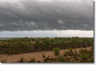
Weather Topic: What are Shelf Clouds?
Home - Education - Cloud Types - Shelf Clouds
 Next Topic: Sleet
A shelf cloud is similar to a wall cloud, but forms at the front
of a storm cloud, instead of at the rear, where wall clouds form.
A shelf cloud is caused by a series of events set into motion by the advancing
storm; first, cool air settles along the ground where precipitation has just fallen.
As the cool air is brought in, the warmer air is displaced, and rises above it,
because it is less dense. When the warmer air reaches the bottom of the storm cloud,
it begins to cool again, and the resulting condensation is a visible shelf cloud.
Next Topic: Sleet
Current conditions powered by WeatherAPI.com


