Weather Alert in Ohio
Air Quality Alert issued June 12 at 12:04AM EDT by NWS Wilmington OH
AREAS AFFECTED: Delaware; Franklin; Licking; Fairfield
DESCRIPTION: The Mid-Ohio Regional Planning Commission has issued an Air Quality Alert for Delaware, Fairfield, Franklin and Licking counties in Central Ohio, from 6 AM this morning to 10 PM EDT this evening. Levels of ozone within the region may approach or exceed unhealthy standards. On Alert days, help reduce ozone by taking the following actions: * Carpool, if possible, bike, walk or take the bus instead of driving alone. * Refuel your vehicle after 8 pm. * Do not idle your vehicle, exhaust contributes to air pollution. * Mow your lawn in the evening hours and avoid the use of gas-powered lawn equipment. For additional information, please visit the Mid-Ohio Regional Planning Commission's website at morpc.org/airquality
INSTRUCTION: N/A
Want more detail? Get the Complete 7 Day and Night Detailed Forecast!
Current U.S. National Radar--Current
The Current National Weather Radar is shown below with a UTC Time (subtract 5 hours from UTC to get Eastern Time).

National Weather Forecast--Current
The Current National Weather Forecast and National Weather Map are shown below.

National Weather Forecast for Tomorrow
Tomorrow National Weather Forecast and Tomorrow National Weather Map are show below.

North America Water Vapor (Moisture)
This map shows recent moisture content over North America. Bright and colored areas show high moisture (ie, clouds); brown indicates very little moisture present; black indicates no moisture.

Weather Topic: What is Sleet?
Home - Education - Precipitation - Sleet
 Next Topic: Snow
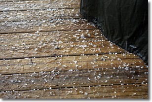
Sleet is a form of precipitation in which small ice pellets are the primary
components. These ice pellets are smaller and more translucent than hailstones,
and harder than graupel. Sleet is caused by specific atmospheric conditions and
therefore typically doesn't last for extended periods of time.
The condition which leads to sleet formation requires a warmer body of air to be
wedged in between two sub-freezing bodies of air. When snow falls through a warmer
layer of air it melts, and as it falls through the next sub-freezing body of air
it freezes again, forming ice pellets known as sleet. In some cases, water
droplets don't have time to freeze before reaching the surface and the result is
freezing rain.
Next Topic: Snow
Weather Topic: What are Stratocumulus Clouds?
Home - Education - Cloud Types - Stratocumulus Clouds
 Next Topic: Stratus Clouds
Stratocumulus clouds are similar to altocumulus clouds in their
fluffy appearance, but have a slightly darker shade due to their additional mass.
A good way to distinguish the two cloud types is to hold your hand out and measure
the size of an individual cloud; if it is the size of your thumb it is generally
an altocumulus cloud, if it is the size of your hand it is generally a
stratocumulus cloud.
It is uncommon for stratocumulus clouds to produce precipitation, but if they do
it is usually a light rain or snow.
Next Topic: Stratus Clouds
Current conditions powered by WeatherAPI.com


