Weather Alert in Iowa
Flood Warning issued August 3 at 10:15AM CDT until August 3 at 5:28PM CDT by NWS Des Moines IA
AREAS AFFECTED: Black Hawk, IA
DESCRIPTION: ...The Flood Warning is extended for the following rivers in Iowa... Iowa River near Tama Hwy E49 affecting Tama and Poweshiek Counties. ...The Flood Warning continues for the following rivers in Iowa... Cedar River at Cedar Falls affecting Black Hawk County. * WHAT...Minor flooding is occurring. * WHERE...The Cedar River at Cedar Falls, or from the West Fork Cedar River to the Cedar Falls-Waterloo city limits. * WHEN...Until this afternoon. * IMPACTS...At 88.8 feet, Water affects the north and south legs of Cottage Row Rd south of Snag Creek. * ADDITIONAL DETAILS... - At 8:45 AM CDT Sunday the stage was 89.2 feet. - Forecast...The river is expected to fall below flood stage late this morning and continue falling. - Flood stage is 89.0 feet.
INSTRUCTION: For the latest waterway observations and forecasts refer to weather.gov/desmoines/water. Turn around, don't drown when encountering flooded roads. Most flood deaths occur in vehicles. River forecasts include observed precipitation plus forecast precipitation over the next 24 hours.
Want more detail? Get the Complete 7 Day and Night Detailed Forecast!
Current U.S. National Radar--Current
The Current National Weather Radar is shown below with a UTC Time (subtract 5 hours from UTC to get Eastern Time).

National Weather Forecast--Current
The Current National Weather Forecast and National Weather Map are shown below.

National Weather Forecast for Tomorrow
Tomorrow National Weather Forecast and Tomorrow National Weather Map are show below.

North America Water Vapor (Moisture)
This map shows recent moisture content over North America. Bright and colored areas show high moisture (ie, clouds); brown indicates very little moisture present; black indicates no moisture.

Weather Topic: What is Freezing Rain?
Home - Education - Precipitation - Freezing Rain
 Next Topic: Graupel
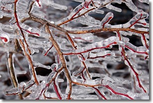
Freezing rain is a condition where precipitation which has fallen in the form of
water droplets reaches temperatures which are below freezing and freezes upon
coming into contact
with surface objects. The result of this precipitation is a glaze of ice which
can be damaging to plants and man-made structures. A severe onset of freezing
rain which results in a very thick glaze of ice is known as an ice storm.
Next Topic: Graupel
Weather Topic: What is Hail?
Home - Education - Precipitation - Hail
 Next Topic: Hole Punch Clouds
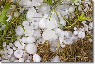
Hail is a form of precipitation which is recognized by large solid balls or
clumps of ice. Hail is created by thunderstorm clouds with strong updrafts of wind.
As the hailstones remain in the updraft, ice is deposited onto them until their
weight becomes heavy enough for them to fall to the earth's surface.
Hail storms can cause significant damage to crops, aircrafts, and man-made structures,
despite the fact that the duration is usually less than ten minutes.
Next Topic: Hole Punch Clouds
Current conditions powered by WeatherAPI.com


