Weather Alert in Arizona
Extreme Heat Watch issued June 11 at 11:30AM MST until June 15 at 7:00PM MST by NWS Flagstaff AZ
AREAS AFFECTED: Grand Canyon Country
DESCRIPTION: * WHAT...Dangerously hot conditions possible below 4000 feet, with daytime temperatures ranging from 103 degrees at Havasupai Gardens, to 110 degrees at Phantom Ranch. * WHERE...Lower Elevations of the Grand Canyon. * WHEN...From Saturday morning through Sunday evening, with the hottest temperatures expected Sunday afternoon. * IMPACTS...Most individuals will be at risk for heat-related illnesses without effective cooling or adequate hydration, especially with prolonged outdoor exposure.
INSTRUCTION: This watch is reserved for only the hottest days of the year and is issued when temperatures could rise to dangerous levels. Day hikers on Bright Angel Trail should descend no farther than 1 1/2 miles from the upper trailhead. Between the hours of 10 AM and 4 PM, hikers should be out of the canyon or at Havasupai Gardens or Bright Angel campgrounds, physical activity is discouraged. All hikers should have adequate gear, including a wide-brimmed hat, sunscreen, salty snacks, sufficient water, and electrolyte mix. Doubling your calorie intake helps maintain your energy. Hike smart.
Want more detail? Get the Complete 7 Day and Night Detailed Forecast!
Current U.S. National Radar--Current
The Current National Weather Radar is shown below with a UTC Time (subtract 5 hours from UTC to get Eastern Time).

National Weather Forecast--Current
The Current National Weather Forecast and National Weather Map are shown below.

National Weather Forecast for Tomorrow
Tomorrow National Weather Forecast and Tomorrow National Weather Map are show below.

North America Water Vapor (Moisture)
This map shows recent moisture content over North America. Bright and colored areas show high moisture (ie, clouds); brown indicates very little moisture present; black indicates no moisture.

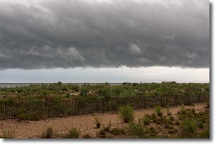
Weather Topic: What are Shelf Clouds?
Home - Education - Cloud Types - Shelf Clouds
 Next Topic: Sleet
A shelf cloud is similar to a wall cloud, but forms at the front
of a storm cloud, instead of at the rear, where wall clouds form.
A shelf cloud is caused by a series of events set into motion by the advancing
storm; first, cool air settles along the ground where precipitation has just fallen.
As the cool air is brought in, the warmer air is displaced, and rises above it,
because it is less dense. When the warmer air reaches the bottom of the storm cloud,
it begins to cool again, and the resulting condensation is a visible shelf cloud.
Next Topic: Sleet
Weather Topic: What is Snow?
Home - Education - Precipitation - Snow
 Next Topic: Stratocumulus Clouds
Snow is precipitation taking the form of ice crystals. Each ice crystal, or snowflake,
has unique characteristics, but all of them grow in a hexagonal structure.
Snowfall can last for sustained periods of time and result in significant buildup
of snow on the ground.
On the earth's surface, snow starts out light and powdery, but as it begins to melt
it tends to become more granular, producing small bits of ice which have the consistency of
sand. After several cycles of melting and freezing, snow can become very dense
and ice-like, commonly known as snow pack.
Next Topic: Stratocumulus Clouds
Current conditions powered by WeatherAPI.com


