Weather Alert in Ohio
Flood Advisory issued April 25 at 5:50PM EDT until April 25 at 9:00PM EDT by NWS Cleveland OH
AREAS AFFECTED: Cuyahoga, OH; Geauga, OH; Lake, OH; Medina, OH; Portage, OH; Summit, OH
DESCRIPTION: * WHAT...Urban and small stream flooding caused by excessive rainfall is expected. * WHERE...A portion of northeast Ohio, including the following counties, Cuyahoga, Geauga, Lake, Medina, Portage and Summit. * WHEN...Until 900 PM EDT. * IMPACTS...Minor flooding in low-lying and poor drainage areas. Some low-water crossings may become impassable. Ponding of water in urban or other areas is occurring or is imminent. * ADDITIONAL DETAILS... - At 550 PM EDT, Doppler radar indicated heavy rain due to thunderstorms. This will cause urban and small stream flooding. Between 1 and 1.5 inches of rain have fallen. - Additional rainfall amounts of 1 to 2 inches are expected over the area. This additional rain will result in minor flooding. - Some locations that will experience flooding include... Cleveland, Akron, Medina, Painesville, Willowick, Fairport Harbor, Parma, Cuyahoga Falls, Euclid, Mentor, Cleveland Heights, Strongsville, Brunswick, North Royalton, Solon, Willoughby, Hudson, Twinsburg, Eastlake and Streetsboro. - Please visit www.weather.gov/safety/flood for flood safety and preparedness information.
INSTRUCTION: Turn around, don't drown when encountering flooded roads. Most flood deaths occur in vehicles. Be aware of your surroundings and do not drive on flooded roads.
Want more detail? Get the Complete 7 Day and Night Detailed Forecast!
Current U.S. National Radar--Current
The Current National Weather Radar is shown below with a UTC Time (subtract 5 hours from UTC to get Eastern Time).

National Weather Forecast--Current
The Current National Weather Forecast and National Weather Map are shown below.

National Weather Forecast for Tomorrow
Tomorrow National Weather Forecast and Tomorrow National Weather Map are show below.

North America Water Vapor (Moisture)
This map shows recent moisture content over North America. Bright and colored areas show high moisture (ie, clouds); brown indicates very little moisture present; black indicates no moisture.

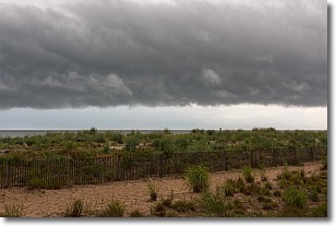
Weather Topic: What are Shelf Clouds?
Home - Education - Cloud Types - Shelf Clouds
 Next Topic: Sleet
A shelf cloud is similar to a wall cloud, but forms at the front
of a storm cloud, instead of at the rear, where wall clouds form.
A shelf cloud is caused by a series of events set into motion by the advancing
storm; first, cool air settles along the ground where precipitation has just fallen.
As the cool air is brought in, the warmer air is displaced, and rises above it,
because it is less dense. When the warmer air reaches the bottom of the storm cloud,
it begins to cool again, and the resulting condensation is a visible shelf cloud.
Next Topic: Sleet
Weather Topic: What is Snow?
Home - Education - Precipitation - Snow
 Next Topic: Stratocumulus Clouds
Snow is precipitation taking the form of ice crystals. Each ice crystal, or snowflake,
has unique characteristics, but all of them grow in a hexagonal structure.
Snowfall can last for sustained periods of time and result in significant buildup
of snow on the ground.
On the earth's surface, snow starts out light and powdery, but as it begins to melt
it tends to become more granular, producing small bits of ice which have the consistency of
sand. After several cycles of melting and freezing, snow can become very dense
and ice-like, commonly known as snow pack.
Next Topic: Stratocumulus Clouds
Current conditions powered by WeatherAPI.com


