Weather Alert in New Mexico
Winter Weather Advisory issued February 18 at 11:21AM MST until February 18 at 11:00PM MST by NWS Albuquerque NM
AREAS AFFECTED: Chuska Mountains; Tusas Mountains Including Chama
DESCRIPTION: * WHAT...Snow expected. Total snow accumulations 2 to 6 inches except up to 9 inches above 8500 feet. Winds gusting as high as 55 mph. * WHERE...Tusas Mountains Including Chama and the Chuska Mountains. * WHEN...Until 11 PM MST this evening. * IMPACTS...Travel could be very difficult. Tire chains may be necessary if traveling through mountain passes. Areas of blowing snow could significantly reduce visibility. Very strong winds could cause extensive damage to trees and power lines. * ADDITIONAL DETAILS...The heaviest snow is forecast for late afternoon in the Chuska Mountains, and this afternoon and evening in the Tusas Mountains, as a cold front crosses from the northwest. Visibility will drop below a half mile at times during periods of snow and blowing snow.
INSTRUCTION: Slow down and use caution while traveling. For the latest road conditions, dial 511 or 1.800.432.4269, or visit http://nmroads.com.
Want more detail? Get the Complete 7 Day and Night Detailed Forecast!
Current U.S. National Radar--Current
The Current National Weather Radar is shown below with a UTC Time (subtract 5 hours from UTC to get Eastern Time).

National Weather Forecast--Current
The Current National Weather Forecast and National Weather Map are shown below.

National Weather Forecast for Tomorrow
Tomorrow National Weather Forecast and Tomorrow National Weather Map are show below.

North America Water Vapor (Moisture)
This map shows recent moisture content over North America. Bright and colored areas show high moisture (ie, clouds); brown indicates very little moisture present; black indicates no moisture.

Weather Topic: What is Fog?
Home - Education - Cloud Types - Fog
 Next Topic: Fractus Clouds
Fog is technically a type of stratus cloud, which lies along the
ground and obscures visibility.
It is usually created when humidity in the air condenses into tiny water droplets.
Because of this, some places are more prone to foggy weather, such as regions
close to a body of water.
Fog is similar to mist; both are the appearance of water droplets suspended in
the air, but fog is the term applied to the condition when visibility is less than 1 km.
Next Topic: Fractus Clouds
Weather Topic: What is Freezing Rain?
Home - Education - Precipitation - Freezing Rain
 Next Topic: Graupel
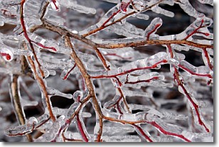
Freezing rain is a condition where precipitation which has fallen in the form of
water droplets reaches temperatures which are below freezing and freezes upon
coming into contact
with surface objects. The result of this precipitation is a glaze of ice which
can be damaging to plants and man-made structures. A severe onset of freezing
rain which results in a very thick glaze of ice is known as an ice storm.
Next Topic: Graupel
Current conditions powered by WeatherAPI.com


