Weather Alert in Arizona
Dust Advisory issued September 2 at 5:14PM MST until September 2 at 6:00PM MST by NWS Phoenix AZ
AREAS AFFECTED: Maricopa, AZ; Pinal, AZ
DESCRIPTION: The National Weather Service in Phoenix has issued a * Dust Advisory for... Maricopa County in south central Arizona... Pinal County in southeastern Arizona... * Until 600 PM MST. * At 514 PM MST, a wall of dust was along a line extending from near San Tan Valley to 8 miles east of Florence to 15 miles northwest of Saddlebrooke Ranch, moving east at 25 mph. HAZARD...Less than three miles visibility with strong wind in excess of 30 mph. SOURCE...Doppler radar. IMPACT...Hazardous travel. * This includes the following highways... AZ Interstate 10 between mile markers 161 and 204. AZ Interstate 8 between mile markers 163 and 178. US Highway 60 between mile markers 202 and 232. Locations impacted include... Mesa, Chandler, Gilbert, Casa Grande, Apache Junction, Florence, Coolidge, Superior, Gold Canyon, Sun Lakes, Maricopa, Queen Creek, Arizona City, La Palma, and San Tan Village Mall.
INSTRUCTION: Blowing dust brings reduced visibility, leading to dangerous driving conditions. If driving, avoid blowing dust if possible. If caught in dense blowing dust, pull off the road, turn off your lights and keep your foot off the brake. Motorists should not drive into an area of blowing dust. PULL ASIDE STAY ALIVE!
Want more detail? Get the Complete 7 Day and Night Detailed Forecast!
Current U.S. National Radar--Current
The Current National Weather Radar is shown below with a UTC Time (subtract 5 hours from UTC to get Eastern Time).

National Weather Forecast--Current
The Current National Weather Forecast and National Weather Map are shown below.

National Weather Forecast for Tomorrow
Tomorrow National Weather Forecast and Tomorrow National Weather Map are show below.

North America Water Vapor (Moisture)
This map shows recent moisture content over North America. Bright and colored areas show high moisture (ie, clouds); brown indicates very little moisture present; black indicates no moisture.

Weather Topic: What are Cirrocumulus Clouds?
Home - Education - Cloud Types - Cirrocumulus Clouds
 Next Topic: Cirrostratus Clouds
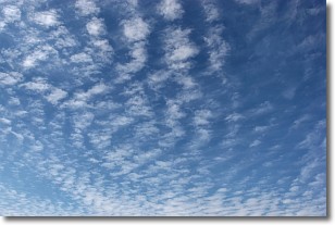
Cirrocumulus clouds form at high altitudes (usually around 5 km)
and have distinguishing characteristics displayed in a fine layer of
small cloud patches. These small cloud patches are sometimes referred to as
"cloudlets" in relation to the whole cloud formation.
Cirrocumulus clouds are formed from ice crystals and water droplets. Often, the
water droplets in the cloud freeze into ice crystals and the cloud becomes a
cirrostratus cloud. Because of this common occurrence, cirrocumulus cloud
formations generally pass rapidly.
Next Topic: Cirrostratus Clouds
Weather Topic: What are Cirrus Clouds?
Home - Education - Cloud Types - Cirrus Clouds
 Next Topic: Condensation
Cirrus clouds are high-level clouds that occur above 20,000 feet
and are composed mainly of ice crystals.
They are thin and wispy in appearance.
What do they indicate?
They are often the first sign of an approaching storm.
Next Topic: Condensation
Current conditions powered by WeatherAPI.com


