Weather Alert in Texas
Flood Advisory issued August 31 at 12:09PM CDT until August 31 at 2:00PM CDT by NWS San Angelo TX
AREAS AFFECTED: Brown, TX
DESCRIPTION: * WHAT...Flooding caused by excessive rainfall is expected. * WHERE...A portion of west central Texas, including the following county, central Brown County. * WHEN...Until 200 PM CDT. * IMPACTS...Minor flooding in low-lying and poor drainage areas. * ADDITIONAL DETAILS... - At 1205 PM CDT, radar indicated a cluster of showers and thunderstorms with very heavy rain moving southeast into the Brownwood area from Lake Brownwood. Rainfall of 1 to 1.5 inches is expected in a short period of time. This will cause street flooding in Brownwood and Early, and flooding of low- lying areas and low-water crossings. - Some locations that will experience flooding include... Brownwood, Early, Camp Bowie and Lake Brownwood. - This includes the following Low Water Crossings... Austin Street at Avenue G, 4th Street at Wood, Gifford at Beaver, Indian Creek at 9th, Willis at Belmeade, Magnolia at Belmeade, Cordell at Anderson, Good Shephard at 11th, Belle Plain at Romines and Austin Street at Avenue J. - http://www.weather.gov/safety/flood
INSTRUCTION: Turn around, don't drown when encountering flooded roads. Most flood deaths occur in vehicles.
Want more detail? Get the Complete 7 Day and Night Detailed Forecast!
Current U.S. National Radar--Current
The Current National Weather Radar is shown below with a UTC Time (subtract 5 hours from UTC to get Eastern Time).

National Weather Forecast--Current
The Current National Weather Forecast and National Weather Map are shown below.

National Weather Forecast for Tomorrow
Tomorrow National Weather Forecast and Tomorrow National Weather Map are show below.

North America Water Vapor (Moisture)
This map shows recent moisture content over North America. Bright and colored areas show high moisture (ie, clouds); brown indicates very little moisture present; black indicates no moisture.

Weather Topic: What is Freezing Rain?
Home - Education - Precipitation - Freezing Rain
 Next Topic: Graupel
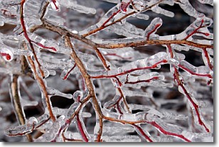
Freezing rain is a condition where precipitation which has fallen in the form of
water droplets reaches temperatures which are below freezing and freezes upon
coming into contact
with surface objects. The result of this precipitation is a glaze of ice which
can be damaging to plants and man-made structures. A severe onset of freezing
rain which results in a very thick glaze of ice is known as an ice storm.
Next Topic: Graupel
Weather Topic: What is Hail?
Home - Education - Precipitation - Hail
 Next Topic: Hole Punch Clouds
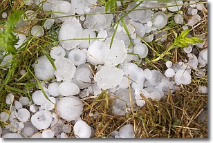
Hail is a form of precipitation which is recognized by large solid balls or
clumps of ice. Hail is created by thunderstorm clouds with strong updrafts of wind.
As the hailstones remain in the updraft, ice is deposited onto them until their
weight becomes heavy enough for them to fall to the earth's surface.
Hail storms can cause significant damage to crops, aircrafts, and man-made structures,
despite the fact that the duration is usually less than ten minutes.
Next Topic: Hole Punch Clouds
Current conditions powered by WeatherAPI.com


