Weather Alert in Wyoming
Winter Weather Advisory issued February 9 at 1:18AM MST until February 9 at 5:00PM MST by NWS Riverton WY
AREAS AFFECTED: Teton and Gros Ventre Mountains
DESCRIPTION: * WHAT...Snow expected. Total snow accumulations of 5 to 12 inches, including over Togwotee and Teton Passes. Locally higher amounts up to 18 inches are possible across the highest terrain of the Tetons. Widespread wind gusts of 20 to 35 mph with the higher terrain of the Tetons seeing gusts up to 50 mph. * WHERE...Teton and Gros Ventre Mountains. * WHEN...Until 5 PM MST this afternoon. * IMPACTS...Travel could be very difficult. The hazardous conditions could impact the Monday morning and evening commutes. * ADDITIONAL DETAILS...The period of heaviest snowfall is forecast to occur through 11 AM Monday with snow rates of 0.5 inch per hour to 1 inch per hour possible.
INSTRUCTION: Slow down and use caution while traveling. For graphical depictions of the snowfall forecast, including the official NWS forecast, high end amounts, and low end amounts, visit https://weather.gov/riw/winter . For winter road conditions from the Wyoming Department of Transportation, visit https://wyoroad.info .
Want more detail? Get the Complete 7 Day and Night Detailed Forecast!
Current U.S. National Radar--Current
The Current National Weather Radar is shown below with a UTC Time (subtract 5 hours from UTC to get Eastern Time).

National Weather Forecast--Current
The Current National Weather Forecast and National Weather Map are shown below.

National Weather Forecast for Tomorrow
Tomorrow National Weather Forecast and Tomorrow National Weather Map are show below.

North America Water Vapor (Moisture)
This map shows recent moisture content over North America. Bright and colored areas show high moisture (ie, clouds); brown indicates very little moisture present; black indicates no moisture.

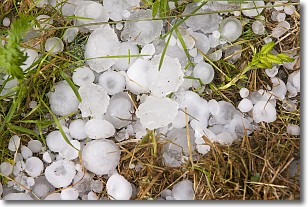
Weather Topic: What is Hail?
Home - Education - Precipitation - Hail
 Next Topic: Hole Punch Clouds
Hail is a form of precipitation which is recognized by large solid balls or
clumps of ice. Hail is created by thunderstorm clouds with strong updrafts of wind.
As the hailstones remain in the updraft, ice is deposited onto them until their
weight becomes heavy enough for them to fall to the earth's surface.
Hail storms can cause significant damage to crops, aircrafts, and man-made structures,
despite the fact that the duration is usually less than ten minutes.
Next Topic: Hole Punch Clouds
Weather Topic: What are Mammatus Clouds?
Home - Education - Cloud Types - Mammatus Clouds
 Next Topic: Nimbostratus Clouds
A mammatus cloud is a cloud with a unique feature which resembles
a web of pouches hanging along the base of the cloud.
In the United States, mammatus clouds tend to form in the warmer months, commonly
in the Midwest and eastern regions.
While they usually form at the bottom of a cumulonimbis cloud, they can also form
under altostratus, altocumulus, stratocumulus, and cirrus clouds. Mammatus clouds
warn that severe weather is close.
Next Topic: Nimbostratus Clouds
Current conditions powered by WeatherAPI.com


