Weather Alert in Kansas
Red Flag Warning issued February 16 at 1:45PM MST until February 17 at 8:00PM MST by NWS Goodland KS
AREAS AFFECTED: Decatur; Norton; Thomas; Sheridan; Graham; Logan; Gove; Wichita; Red Willow
DESCRIPTION: For Tuesday, low relative humidity and sustained winds around 40 mph will lead to extreme fire spread for any fires that ignite. Southwest winds will change to west behind a cold front in the afternoon. Blowing dust may also occur near open fields or other source regions causing reductions in visibility and poor air quality. * AFFECTED AREA...Fire Weather Zones 003 Decatur, 004 Norton, 014 Thomas, 015 Sheridan, 016 Graham, 028 Logan, 029 Gove, 042 Wichita and 081 Red Willow. * TIMING...From 11 AM to 9 PM CST Tuesday. * WINDS...West 30 to 40 mph with gusts up to 60 mph. * RELATIVE HUMIDITY...As low as 10 percent. * IMPACTS...Extremely dangerous and erratic fire behavior. Any fires that develop will rapidly grow and spread out of control.
INSTRUCTION: Comply with burn bans and regulations. Avoid driving on dry grass or brush. Maintain vehicle brakes and tires and secure tow chains to avoid dragging. Never toss lit cigarettes onto the ground. Evacuate if fire/smoke is heading your way, or if ordered to do so by local officials.
Want more detail? Get the Complete 7 Day and Night Detailed Forecast!
Current U.S. National Radar--Current
The Current National Weather Radar is shown below with a UTC Time (subtract 5 hours from UTC to get Eastern Time).

National Weather Forecast--Current
The Current National Weather Forecast and National Weather Map are shown below.

National Weather Forecast for Tomorrow
Tomorrow National Weather Forecast and Tomorrow National Weather Map are show below.

North America Water Vapor (Moisture)
This map shows recent moisture content over North America. Bright and colored areas show high moisture (ie, clouds); brown indicates very little moisture present; black indicates no moisture.

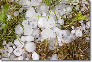
Weather Topic: What is Hail?
Home - Education - Precipitation - Hail
 Next Topic: Hole Punch Clouds
Hail is a form of precipitation which is recognized by large solid balls or
clumps of ice. Hail is created by thunderstorm clouds with strong updrafts of wind.
As the hailstones remain in the updraft, ice is deposited onto them until their
weight becomes heavy enough for them to fall to the earth's surface.
Hail storms can cause significant damage to crops, aircrafts, and man-made structures,
despite the fact that the duration is usually less than ten minutes.
Next Topic: Hole Punch Clouds
Weather Topic: What are Mammatus Clouds?
Home - Education - Cloud Types - Mammatus Clouds
 Next Topic: Nimbostratus Clouds
A mammatus cloud is a cloud with a unique feature which resembles
a web of pouches hanging along the base of the cloud.
In the United States, mammatus clouds tend to form in the warmer months, commonly
in the Midwest and eastern regions.
While they usually form at the bottom of a cumulonimbis cloud, they can also form
under altostratus, altocumulus, stratocumulus, and cirrus clouds. Mammatus clouds
warn that severe weather is close.
Next Topic: Nimbostratus Clouds
Current conditions powered by WeatherAPI.com


