Weather Alert in Illinois
Flood Warning issued March 9 at 11:45AM EDT by NWS Indianapolis IN
AREAS AFFECTED: Edwards, IL; Gallatin, IL; Wabash, IL; White, IL; Gibson, IN; Knox, IN; Posey, IN
DESCRIPTION: ...The Flood Warning is extended for the following rivers in Indiana...Illinois... White River at Edwardsport. White River at Newberry. White River at Elliston. Wabash River at Mount Carmel. ...The Flood Warning continues for the following rivers in Indiana... White River at Hazleton. White River at Petersburg. .Minor to moderate flooding continue on the White River and minor flooding continues on the lower Wabash at Mount Carmel due to heavy rainfall last week. Additional rainfall of one to two inches Tuesday through Wednesday is expected to bring additional rises on the White and lengthen the amount of time in flood for the lower White. Additional flooding is possible on the lower Wabash as well, depending on the exact location of the rainfall. The crest on the White is near Edwardsport Monday morning and expected to reach Hazleton sometime Friday. * WHAT...Minor flooding is occurring and minor flooding is forecast. * WHERE...Wabash River at Mount Carmel. * WHEN...Until further notice. * IMPACTS...At 24.0 feet, Extensive lowland flooding in progress. Some mobile homes must be moved if water rises higher. Installation of flood gate A at Mount Carmel is necessary. Access to local camp sites are blocked, but minimal impact to commercial activities because of gate closure. In Wabash County Illinois, CR 1280 E and South Division Street are flooded. * ADDITIONAL DETAILS... - At 10:45 AM EDT Monday /9:45 AM CDT Monday/ the stage was 19.9 feet. - Recent Activity...The maximum river stage in the 24 hours ending at 10:45 AM EDT Monday /9:45 AM CDT Monday/ was 19.9 feet. - Forecast...The river is expected to rise to a crest of 24.4 feet Sunday evening. - Flood stage is 19.0 feet. - http://www.weather.gov/safety/flood
INSTRUCTION: Turn around, don't drown when encountering flooded roads. Most flood deaths occur in vehicles. Motorists should not attempt to drive around barricades or drive cars through flooded areas. Additional information is available at www.weather.gov/ind. The next statement should be issued this evening by around 1115 PM EDT /1015 PM CDT/.
Want more detail? Get the Complete 7 Day and Night Detailed Forecast!
Current U.S. National Radar--Current
The Current National Weather Radar is shown below with a UTC Time (subtract 5 hours from UTC to get Eastern Time).

National Weather Forecast--Current
The Current National Weather Forecast and National Weather Map are shown below.

National Weather Forecast for Tomorrow
Tomorrow National Weather Forecast and Tomorrow National Weather Map are show below.

North America Water Vapor (Moisture)
This map shows recent moisture content over North America. Bright and colored areas show high moisture (ie, clouds); brown indicates very little moisture present; black indicates no moisture.

Weather Topic: What is Fog?
Home - Education - Cloud Types - Fog
 Next Topic: Fractus Clouds
Fog is technically a type of stratus cloud, which lies along the
ground and obscures visibility.
It is usually created when humidity in the air condenses into tiny water droplets.
Because of this, some places are more prone to foggy weather, such as regions
close to a body of water.
Fog is similar to mist; both are the appearance of water droplets suspended in
the air, but fog is the term applied to the condition when visibility is less than 1 km.
Next Topic: Fractus Clouds
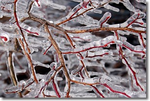
Weather Topic: What is Freezing Rain?
Home - Education - Precipitation - Freezing Rain
 Next Topic: Graupel
Freezing rain is a condition where precipitation which has fallen in the form of
water droplets reaches temperatures which are below freezing and freezes upon
coming into contact
with surface objects. The result of this precipitation is a glaze of ice which
can be damaging to plants and man-made structures. A severe onset of freezing
rain which results in a very thick glaze of ice is known as an ice storm.
Next Topic: Graupel
Current conditions powered by WeatherAPI.com


