Weather Alert in Missouri
Flood Warning issued March 9 at 10:05AM CDT until March 12 at 4:41AM CDT by NWS St Louis MO
AREAS AFFECTED: Jefferson, MO; St. Louis, MO
DESCRIPTION: ...The Flood Warning is extended for the following rivers in Illinois...Missouri... Kaskaskia River at Carlyle. Meramec River at Valley Park. Meramec River near Eureka. Meramec River near Sullivan. River forecasts are based on observed precipitation and forecast precipitation for the next 48 hours. * WHAT...Minor flooding is occurring and minor flooding is forecast. * WHERE...Meramec River near Eureka. * WHEN...Until late Wednesday night. * IMPACTS...At 22.0 feet, Willman Road near the Highway 109 bridge becomes inundated and impassable. * ADDITIONAL DETAILS... - At 9:30 AM CDT Monday the stage was 21.3 feet. - Recent Activity...The maximum river stage in the 24 hours ending at 9:30 AM CDT Monday was 23.2 feet. - Forecast...The river will fall to 21.2 feet this afternoon. It will then rise to 21.7 feet tomorrow morning. It will fall below flood stage late tomorrow evening to 8.3 feet early Saturday afternoon then rise again. - Flood stage is 19.0 feet.
INSTRUCTION: Turn around, don't drown when encountering flooded roads. Most flood deaths occur in vehicles. Motorists should not attempt to drive around barricades or drive cars through flooded areas. Be especially cautious at night when it is harder to recognize the dangers of flooding. Rainfall heavier than forecast could cause river levels to rise even higher than predicted. The National Weather Service will monitor this developing situation and issue follow up statements as conditions change. This product, along with additional weather and stream information, is available at https://water.noaa.gov/wfo/lsx
Want more detail? Get the Complete 7 Day and Night Detailed Forecast!
Current U.S. National Radar--Current
The Current National Weather Radar is shown below with a UTC Time (subtract 5 hours from UTC to get Eastern Time).

National Weather Forecast--Current
The Current National Weather Forecast and National Weather Map are shown below.

National Weather Forecast for Tomorrow
Tomorrow National Weather Forecast and Tomorrow National Weather Map are show below.

North America Water Vapor (Moisture)
This map shows recent moisture content over North America. Bright and colored areas show high moisture (ie, clouds); brown indicates very little moisture present; black indicates no moisture.

Weather Topic: What is Precipitation?
Home - Education - Precipitation - Precipitation
 Next Topic: Rain
Precipitation can refer to many different forms of water that
may fall from clouds. Precipitation occurs after a cloud has become saturated to
the point where its water particles are more dense than the air below the cloud.
In most cases, precipitation will reach the ground, but it is not uncommon for
precipitation to evaporate before it reaches the earth's surface.
When precipitation evaporates before it contacts the ground it is called Virga.
Graupel, hail, sleet, rain, drizzle, and snow are forms of precipitation, but fog
and mist are not considered precipitation because the water vapor which
constitutes them isn't dense enough to fall to the ground.
Next Topic: Rain
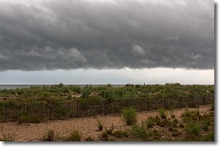
Weather Topic: What are Shelf Clouds?
Home - Education - Cloud Types - Shelf Clouds
 Next Topic: Sleet
A shelf cloud is similar to a wall cloud, but forms at the front
of a storm cloud, instead of at the rear, where wall clouds form.
A shelf cloud is caused by a series of events set into motion by the advancing
storm; first, cool air settles along the ground where precipitation has just fallen.
As the cool air is brought in, the warmer air is displaced, and rises above it,
because it is less dense. When the warmer air reaches the bottom of the storm cloud,
it begins to cool again, and the resulting condensation is a visible shelf cloud.
Next Topic: Sleet
Current conditions powered by WeatherAPI.com


