Weather Alert in Kansas
Flood Warning issued February 15 at 7:51AM CST until February 16 at 9:00AM CST by NWS Topeka KS
AREAS AFFECTED: Franklin, KS
DESCRIPTION: * WHAT...Flooding caused by the Marais Des Cygnes River rising above flood stage of 20 feet. * WHERE...A portion of east central Kansas, including the following county, Franklin. * WHEN...Until 900 AM CST Monday. * IMPACTS...Flooding of the Marais Des Cygnes River, northeast of Pomona will continue through the mid morning hours of Monday. * ADDITIONAL DETAILS... - At 747 AM CST, Flooding is occurring along the Marais Des Cygnes River bank northeast of Pomona. - At 730 AM CST, the Marais Des Cygnes River, northeast of Pomona was at 22.39 feet and may crest around 24 feet this afternoon. - Some locations that will experience flooding include... mainly rural areas of Western Franklin County along the Marais Des Cygnes river northeast of Pomona.
INSTRUCTION: Turn around, don't drown when encountering flooded roads. Most flood deaths occur in vehicles.
Want more detail? Get the Complete 7 Day and Night Detailed Forecast!
Current U.S. National Radar--Current
The Current National Weather Radar is shown below with a UTC Time (subtract 5 hours from UTC to get Eastern Time).

National Weather Forecast--Current
The Current National Weather Forecast and National Weather Map are shown below.

National Weather Forecast for Tomorrow
Tomorrow National Weather Forecast and Tomorrow National Weather Map are show below.

North America Water Vapor (Moisture)
This map shows recent moisture content over North America. Bright and colored areas show high moisture (ie, clouds); brown indicates very little moisture present; black indicates no moisture.

Weather Topic: What is Precipitation?
Home - Education - Precipitation - Precipitation
 Next Topic: Rain
Precipitation can refer to many different forms of water that
may fall from clouds. Precipitation occurs after a cloud has become saturated to
the point where its water particles are more dense than the air below the cloud.
In most cases, precipitation will reach the ground, but it is not uncommon for
precipitation to evaporate before it reaches the earth's surface.
When precipitation evaporates before it contacts the ground it is called Virga.
Graupel, hail, sleet, rain, drizzle, and snow are forms of precipitation, but fog
and mist are not considered precipitation because the water vapor which
constitutes them isn't dense enough to fall to the ground.
Next Topic: Rain
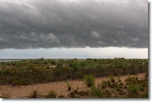
Weather Topic: What are Shelf Clouds?
Home - Education - Cloud Types - Shelf Clouds
 Next Topic: Sleet
A shelf cloud is similar to a wall cloud, but forms at the front
of a storm cloud, instead of at the rear, where wall clouds form.
A shelf cloud is caused by a series of events set into motion by the advancing
storm; first, cool air settles along the ground where precipitation has just fallen.
As the cool air is brought in, the warmer air is displaced, and rises above it,
because it is less dense. When the warmer air reaches the bottom of the storm cloud,
it begins to cool again, and the resulting condensation is a visible shelf cloud.
Next Topic: Sleet
Current conditions powered by WeatherAPI.com


