Weather Alert in New York
Flood Watch issued March 9 at 1:52PM EDT until March 12 at 2:00PM EDT by NWS Burlington VT
AREAS AFFECTED: Northern St. Lawrence; Northern Franklin; Eastern Clinton; Southeastern St. Lawrence; Southern Franklin; Western Clinton; Western Essex; Eastern Essex; Southwestern St. Lawrence; Grand Isle; Western Franklin; Orleans; Essex; Western Chittenden; Lamoille; Caledonia; Washington; Western Addison; Orange; Western Rutland; Eastern Franklin; Eastern Chittenden; Eastern Addison; Eastern Rutland; Western Windsor; Eastern Windsor
DESCRIPTION: Warm temperatures may melt snowpack and increase river flows. * WHAT...Flooding caused by a combination of rain, snowmelt, and ice jams is possible. * WHERE...All of northern New York and northern and central Vermont. * WHEN...Through Thursday afternoon. * IMPACTS...Excessive runoff from snowmelt and rainfall will cause sharp river rises, likely resulting in river ice break up. Ice jams will be possible, along with rapid onset flooding. Flooding of rivers, creeks, streams, and other low-lying and flood-prone locations will be possible and creeks and streams may rise out of their banks. * ADDITIONAL DETAILS... - Mild temperatures will lead to rapid rises on area rivers through early this week. This will be followed by widespread rain Wednesday into Thursday. Rising rivers will cause river ice to break up and flow, potentially resulting in ice jams and associated flooding. As rain moves in Wednesday, the threat will turn more toward open water flooding for those waterways that have lost their ice. Any open water flooding will likely persist through Thursday. - http://www.weather.gov/safety/flood
INSTRUCTION: You should monitor later forecasts and be alert for possible Flood Warnings. Those living in areas prone to flooding should be prepared to take action should flooding develop.
Want more detail? Get the Complete 7 Day and Night Detailed Forecast!
Current U.S. National Radar--Current
The Current National Weather Radar is shown below with a UTC Time (subtract 5 hours from UTC to get Eastern Time).

National Weather Forecast--Current
The Current National Weather Forecast and National Weather Map are shown below.

National Weather Forecast for Tomorrow
Tomorrow National Weather Forecast and Tomorrow National Weather Map are show below.

North America Water Vapor (Moisture)
This map shows recent moisture content over North America. Bright and colored areas show high moisture (ie, clouds); brown indicates very little moisture present; black indicates no moisture.

Weather Topic: What is Fog?
Home - Education - Cloud Types - Fog
 Next Topic: Fractus Clouds
Fog is technically a type of stratus cloud, which lies along the
ground and obscures visibility.
It is usually created when humidity in the air condenses into tiny water droplets.
Because of this, some places are more prone to foggy weather, such as regions
close to a body of water.
Fog is similar to mist; both are the appearance of water droplets suspended in
the air, but fog is the term applied to the condition when visibility is less than 1 km.
Next Topic: Fractus Clouds
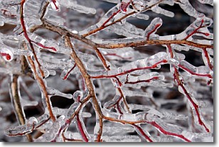
Weather Topic: What is Freezing Rain?
Home - Education - Precipitation - Freezing Rain
 Next Topic: Graupel
Freezing rain is a condition where precipitation which has fallen in the form of
water droplets reaches temperatures which are below freezing and freezes upon
coming into contact
with surface objects. The result of this precipitation is a glaze of ice which
can be damaging to plants and man-made structures. A severe onset of freezing
rain which results in a very thick glaze of ice is known as an ice storm.
Next Topic: Graupel
Current conditions powered by WeatherAPI.com


