Weather Alert in Maryland
Coastal Flood Advisory issued August 23 at 2:10PM EDT until August 25 at 6:00AM EDT by NWS Baltimore MD/Washington DC
AREAS AFFECTED: Southern Baltimore; Calvert; Southeast Harford
DESCRIPTION: * WHAT...One and a half of two feet of inundation above ground level in low lying areas due to tidal flooding. * WHERE...Southern Baltimore, Calvert and Southeast Harford Counties. * WHEN...Until 6 AM EDT Monday, especially around the time of high tide. * IMPACTS...At 3.5 feet, flooding is occurring at the end of Thames Street in Baltimore. Water covers the promenade in the Inner Harbor in multiple locations. At 3.0 feet, water begins encroaching upon yards in the Bowleys Quarters area. At 4.5 feet, portions of the Havre de Grace Yacht Basin are flooded, along with Hutchins Park. At 3.0 feet, water is expected to reach backyards near 9th Street in North Beach, and could approach 9th Street. At 3.0 feet, parking lots near Charles Street in Solomons begin to flood, with several inches of water covering low-lying portions of Charles Street and Williams Street. * ADDITIONAL DETAILS...Tides two to two and a half feet above normal. The next high tide at Chesapeake Beach is at 4:53 PM and 5:24 AM. The next high tide at Havre de Grace is at 11:02 PM and 11:10 AM. The next high tide at Solomons Island is at 3:04 PM and 3:36 AM. The next high tide at Fort McHenry Baltimore is at 7:40 PM and 8:11 AM.
INSTRUCTION: If travel is required, allow extra time as some roads may be closed. Do not drive around barricades or through water of unknown depth. Take the necessary actions to protect flood-prone property.
Want more detail? Get the Complete 7 Day and Night Detailed Forecast!
Current U.S. National Radar--Current
The Current National Weather Radar is shown below with a UTC Time (subtract 5 hours from UTC to get Eastern Time).

National Weather Forecast--Current
The Current National Weather Forecast and National Weather Map are shown below.

National Weather Forecast for Tomorrow
Tomorrow National Weather Forecast and Tomorrow National Weather Map are show below.

North America Water Vapor (Moisture)
This map shows recent moisture content over North America. Bright and colored areas show high moisture (ie, clouds); brown indicates very little moisture present; black indicates no moisture.

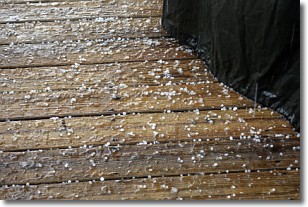
Weather Topic: What is Sleet?
Home - Education - Precipitation - Sleet
 Next Topic: Snow
Sleet is a form of precipitation in which small ice pellets are the primary
components. These ice pellets are smaller and more translucent than hailstones,
and harder than graupel. Sleet is caused by specific atmospheric conditions and
therefore typically doesn't last for extended periods of time.
The condition which leads to sleet formation requires a warmer body of air to be
wedged in between two sub-freezing bodies of air. When snow falls through a warmer
layer of air it melts, and as it falls through the next sub-freezing body of air
it freezes again, forming ice pellets known as sleet. In some cases, water
droplets don't have time to freeze before reaching the surface and the result is
freezing rain.
Next Topic: Snow
Weather Topic: What are Stratocumulus Clouds?
Home - Education - Cloud Types - Stratocumulus Clouds
 Next Topic: Stratus Clouds
Stratocumulus clouds are similar to altocumulus clouds in their
fluffy appearance, but have a slightly darker shade due to their additional mass.
A good way to distinguish the two cloud types is to hold your hand out and measure
the size of an individual cloud; if it is the size of your thumb it is generally
an altocumulus cloud, if it is the size of your hand it is generally a
stratocumulus cloud.
It is uncommon for stratocumulus clouds to produce precipitation, but if they do
it is usually a light rain or snow.
Next Topic: Stratus Clouds
Current conditions powered by WeatherAPI.com


