Weather Alert in Oregon
Fire Weather Watch issued September 4 at 1:41PM PDT until September 5 at 11:00PM PDT by NWS Pendleton OR
AREAS AFFECTED: John Day Valley; Central Blue Mountains; Southern Blue Mountains; Western Forested Blue Mountains; Warm Springs Reservation
DESCRIPTION: ...HOT, DRY, AND UNSTABLE CONDITIONS ALONG THE WASHINGTON CASCADES TODAY... ...ISOLATED TO SCATTERED THUNDERSTORMS IN CENTRAL AND EASTERN OREGON FRIDAY... .Hot, dry, and unstable conditions will lead to the potential for rapid fire growth on new and existing fires along the Washington Cascades this afternoon and evening. Farther south, isolated to scattered thunderstorms capable of producing abundant cloud-to- ground lightning are forecast Friday for much of central and eastern Oregon. The National Weather Service in Pendleton has issued a Fire Weather Watch for abundant lightning, which is in effect from Friday afternoon through Friday evening. * AFFECTED AREA...Fire Weather Zones 696 John Day Valley, 697 Central Blue Mountains, 698 Southern Blue Mountains, 699 Western Forested Blue Mountains and 703 Warm Springs Reservation. * TIMING...From Friday afternoon through Friday evening. * IMPACTS...Any fire that develops will catch and spread quickly. Outdoor burning is not recommended. * THUNDERSTORMS...Isolated to scattered thunderstorms capable of producing abundant cloud-to-ground lightning and gusty outflow winds. * OUTFLOW WINDS...Gusts up to 50 mph.
INSTRUCTION: A Fire Weather Watch means that critical fire weather conditions are forecast to occur. Listen for later forecasts and possible Red Flag Warnings.
Want more detail? Get the Complete 7 Day and Night Detailed Forecast!
Current U.S. National Radar--Current
The Current National Weather Radar is shown below with a UTC Time (subtract 5 hours from UTC to get Eastern Time).

National Weather Forecast--Current
The Current National Weather Forecast and National Weather Map are shown below.

National Weather Forecast for Tomorrow
Tomorrow National Weather Forecast and Tomorrow National Weather Map are show below.

North America Water Vapor (Moisture)
This map shows recent moisture content over North America. Bright and colored areas show high moisture (ie, clouds); brown indicates very little moisture present; black indicates no moisture.

Weather Topic: What is Freezing Rain?
Home - Education - Precipitation - Freezing Rain
 Next Topic: Graupel
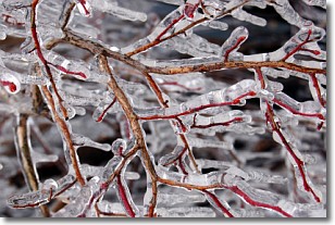
Freezing rain is a condition where precipitation which has fallen in the form of
water droplets reaches temperatures which are below freezing and freezes upon
coming into contact
with surface objects. The result of this precipitation is a glaze of ice which
can be damaging to plants and man-made structures. A severe onset of freezing
rain which results in a very thick glaze of ice is known as an ice storm.
Next Topic: Graupel
Weather Topic: What is Hail?
Home - Education - Precipitation - Hail
 Next Topic: Hole Punch Clouds
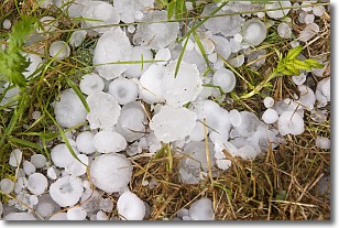
Hail is a form of precipitation which is recognized by large solid balls or
clumps of ice. Hail is created by thunderstorm clouds with strong updrafts of wind.
As the hailstones remain in the updraft, ice is deposited onto them until their
weight becomes heavy enough for them to fall to the earth's surface.
Hail storms can cause significant damage to crops, aircrafts, and man-made structures,
despite the fact that the duration is usually less than ten minutes.
Next Topic: Hole Punch Clouds
Current conditions powered by WeatherAPI.com


