Weather Alert in California
Flood Watch issued February 23 at 3:04PM PST until February 24 at 10:00PM PST by NWS Eureka CA
AREAS AFFECTED: Southeastern Mendocino Interior
DESCRIPTION: ...The National Weather Service in Eureka has issued a Flood Watch for the following rivers in California... Russian River near Hopland affecting Southeastern Mendocino Interior zone. For the Russian River...including Hopland...flooding is possible. * WHAT...Flooding is possible. * WHERE...Russian River near Hopland. * WHEN...From Tuesday afternoon to Tuesday evening. * IMPACTS...At 15.0 feet, Flooding of Highway 175 is expected at the approaches to the Russian River bridge. Expect flooding of cropland on the right bank of river. * ADDITIONAL DETAILS... - At 2:45 PM PST Monday the stage was 3.5 feet. - Forecast...Flood stage may be reached tomorrow afternoon. - Flood stage is 15.0 feet. - http://www.weather.gov/safety/flood
INSTRUCTION: If you are in the watch area, remain alert to possible flooding. Residents and those with interests near the river should monitor rising water levels and be prepared for possible Flood Warnings. Please report observed flooding to local emergency services or law enforcement and request they pass this information to the National Weather Service when you can do so safely. Stay tuned to further developments by listening to your local radio, television, or NOAA Weather Radio for further information. Additional information is available at weather.gov/eka. The next statement will be issued this evening at 1115 PM PST.
Want more detail? Get the Complete 7 Day and Night Detailed Forecast!
Current U.S. National Radar--Current
The Current National Weather Radar is shown below with a UTC Time (subtract 5 hours from UTC to get Eastern Time).

National Weather Forecast--Current
The Current National Weather Forecast and National Weather Map are shown below.

National Weather Forecast for Tomorrow
Tomorrow National Weather Forecast and Tomorrow National Weather Map are show below.

North America Water Vapor (Moisture)
This map shows recent moisture content over North America. Bright and colored areas show high moisture (ie, clouds); brown indicates very little moisture present; black indicates no moisture.

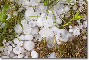
Weather Topic: What is Hail?
Home - Education - Precipitation - Hail
 Next Topic: Hole Punch Clouds
Hail is a form of precipitation which is recognized by large solid balls or
clumps of ice. Hail is created by thunderstorm clouds with strong updrafts of wind.
As the hailstones remain in the updraft, ice is deposited onto them until their
weight becomes heavy enough for them to fall to the earth's surface.
Hail storms can cause significant damage to crops, aircrafts, and man-made structures,
despite the fact that the duration is usually less than ten minutes.
Next Topic: Hole Punch Clouds
Weather Topic: What are Mammatus Clouds?
Home - Education - Cloud Types - Mammatus Clouds
 Next Topic: Nimbostratus Clouds
A mammatus cloud is a cloud with a unique feature which resembles
a web of pouches hanging along the base of the cloud.
In the United States, mammatus clouds tend to form in the warmer months, commonly
in the Midwest and eastern regions.
While they usually form at the bottom of a cumulonimbis cloud, they can also form
under altostratus, altocumulus, stratocumulus, and cirrus clouds. Mammatus clouds
warn that severe weather is close.
Next Topic: Nimbostratus Clouds
Current conditions powered by WeatherAPI.com


