Weather Alert in Arizona
Fire Weather Watch issued April 25 at 1:01AM MST until April 27 at 8:00PM MST by NWS Tucson AZ
AREAS AFFECTED: Eastern Pima-Southeastern Pinal-Santa Cruz-Western Cochise; Southern Graham-Central and Eastern Cochise-Southern Greenlee-Lower Elevations of the San Carlos Apache Nation in Graham County; Northern Graham-Northern Greenlee-White and Gila Mountains; Mountains above 5500 feet
DESCRIPTION: * AFFECTED AREA...Fire Weather Zones 151, 152, 153 and 154. Which includes the Sky Islands of Southeast Arizona, Cochise, Graham, Greenlee, Santa Cruz, and eastern potions of Pinal and Pima Counties. * TIMING...From Sunday morning through Sunday evening. * WINDS...Southwest 20 to 30 mph with gusts up to 45 mph. * RELATIVE HUMIDITY...6 to 10 percent. * IMPACTS...Any fires that develop or are ongoing will have the potential to spread rapidly.
INSTRUCTION: A Fire Weather Watch means that critical fire weather conditions are forecast to occur. Listen for later forecasts and possible Red Flag Warnings. Please advise the appropriate officials or fire crews in the field of the Fire Weather Watch for portions of Southeast Arizona.
Want more detail? Get the Complete 7 Day and Night Detailed Forecast!
Current U.S. National Radar--Current
The Current National Weather Radar is shown below with a UTC Time (subtract 5 hours from UTC to get Eastern Time).

National Weather Forecast--Current
The Current National Weather Forecast and National Weather Map are shown below.

National Weather Forecast for Tomorrow
Tomorrow National Weather Forecast and Tomorrow National Weather Map are show below.

North America Water Vapor (Moisture)
This map shows recent moisture content over North America. Bright and colored areas show high moisture (ie, clouds); brown indicates very little moisture present; black indicates no moisture.

Weather Topic: What is Fog?
Home - Education - Cloud Types - Fog
 Next Topic: Fractus Clouds
Fog is technically a type of stratus cloud, which lies along the
ground and obscures visibility.
It is usually created when humidity in the air condenses into tiny water droplets.
Because of this, some places are more prone to foggy weather, such as regions
close to a body of water.
Fog is similar to mist; both are the appearance of water droplets suspended in
the air, but fog is the term applied to the condition when visibility is less than 1 km.
Next Topic: Fractus Clouds
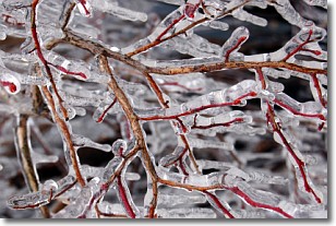
Weather Topic: What is Freezing Rain?
Home - Education - Precipitation - Freezing Rain
 Next Topic: Graupel
Freezing rain is a condition where precipitation which has fallen in the form of
water droplets reaches temperatures which are below freezing and freezes upon
coming into contact
with surface objects. The result of this precipitation is a glaze of ice which
can be damaging to plants and man-made structures. A severe onset of freezing
rain which results in a very thick glaze of ice is known as an ice storm.
Next Topic: Graupel
Current conditions powered by WeatherAPI.com


