Weather Alert in Washington
Winter Storm Warning issued March 7 at 11:47PM PST until March 10 at 5:00AM PDT by NWS Seattle WA
AREAS AFFECTED: Cascades of Whatcom and Skagit Counties; Cascades of Snohomish and Northern King Counties
DESCRIPTION: * WHAT...For the Winter Weather Advisory, snow expected. Total snow accumulations up to 4 to 8 inches. Winds gusting as high as 35 mph. For the Winter Storm Warning, heavy snow possible. Total snow accumulations between 12 and 18 inches possible. Winds gusting as high as 35 mph. * WHERE...Cascades of Snohomish and Northern King Counties and Cascades of Whatcom and Skagit Counties. * WHEN...For the Winter Weather Advisory, from 5 AM to 1 PM PDT Sunday. For the Winter Storm Warning, from 5 PM Sunday to 5 AM PDT Tuesday. * IMPACTS...Snow-covered roads may make travel conditions difficult at times through the mountains and cause delays. Temporary road closures possible. Gusty winds may limit visibility at times and down tree branches.
INSTRUCTION: If you must travel, keep an extra flashlight, food, and water in your vehicle in case of an emergency. Prepare for possible power outages. Slow down and use caution while traveling. Prepare for possible power outages.
Want more detail? Get the Complete 7 Day and Night Detailed Forecast!
Current U.S. National Radar--Current
The Current National Weather Radar is shown below with a UTC Time (subtract 5 hours from UTC to get Eastern Time).

National Weather Forecast--Current
The Current National Weather Forecast and National Weather Map are shown below.

National Weather Forecast for Tomorrow
Tomorrow National Weather Forecast and Tomorrow National Weather Map are show below.

North America Water Vapor (Moisture)
This map shows recent moisture content over North America. Bright and colored areas show high moisture (ie, clouds); brown indicates very little moisture present; black indicates no moisture.

Weather Topic: What is Precipitation?
Home - Education - Precipitation - Precipitation
 Next Topic: Rain
Precipitation can refer to many different forms of water that
may fall from clouds. Precipitation occurs after a cloud has become saturated to
the point where its water particles are more dense than the air below the cloud.
In most cases, precipitation will reach the ground, but it is not uncommon for
precipitation to evaporate before it reaches the earth's surface.
When precipitation evaporates before it contacts the ground it is called Virga.
Graupel, hail, sleet, rain, drizzle, and snow are forms of precipitation, but fog
and mist are not considered precipitation because the water vapor which
constitutes them isn't dense enough to fall to the ground.
Next Topic: Rain
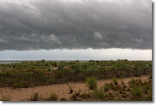
Weather Topic: What are Shelf Clouds?
Home - Education - Cloud Types - Shelf Clouds
 Next Topic: Sleet
A shelf cloud is similar to a wall cloud, but forms at the front
of a storm cloud, instead of at the rear, where wall clouds form.
A shelf cloud is caused by a series of events set into motion by the advancing
storm; first, cool air settles along the ground where precipitation has just fallen.
As the cool air is brought in, the warmer air is displaced, and rises above it,
because it is less dense. When the warmer air reaches the bottom of the storm cloud,
it begins to cool again, and the resulting condensation is a visible shelf cloud.
Next Topic: Sleet
Current conditions powered by WeatherAPI.com


