Weather Alert in Nebraska
Red Flag Warning issued February 8 at 2:50PM CST until February 9 at 6:00PM CST by NWS North Platte NE
AREAS AFFECTED: Eastern Panhandle/Crescent Lake NWR; Sandhills/Valentine NWR/Nebraska National Forest
DESCRIPTION: The National Weather Service in North Platte has issued a Red Flag Warning for gusty west winds, warm temperatures and low relative humidity, which is in effect from 9 AM CST /8 AM MST/ to 6 PM CST /5 PM MST/ Monday. * AFFECTED AREA...Fire Weather Zone 204, Eastern Panhandle/Crescent Lake NWR and Fire Weather Zone 206, Sandhills/Valentine NWR/Nebraska National Forest. * TIMING...From mid-morning Monday through the afternoon hours. * WINDS...West 10 to 20 mph with gusts up to 40 mph. Highest gusts in the western Sandhills. * RELATIVE HUMIDITY...As low as 15 percent. * TEMPERATURES...Upper 60s to mid 70s. * IMPACTS...Any fire starts will have the potential for quick growth and rapid spread and may be difficult to control.
INSTRUCTION: A Red Flag Warning means that critical fire weather conditions are either occurring now, or will shortly. A combination of strong winds, low relative humidity, and warm temperatures can contribute to extreme fire behavior.
Want more detail? Get the Complete 7 Day and Night Detailed Forecast!
Current U.S. National Radar--Current
The Current National Weather Radar is shown below with a UTC Time (subtract 5 hours from UTC to get Eastern Time).

National Weather Forecast--Current
The Current National Weather Forecast and National Weather Map are shown below.

National Weather Forecast for Tomorrow
Tomorrow National Weather Forecast and Tomorrow National Weather Map are show below.

North America Water Vapor (Moisture)
This map shows recent moisture content over North America. Bright and colored areas show high moisture (ie, clouds); brown indicates very little moisture present; black indicates no moisture.

Weather Topic: What is Hail?
Home - Education - Precipitation - Hail
 Next Topic: Hole Punch Clouds
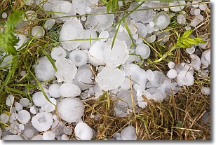
Hail is a form of precipitation which is recognized by large solid balls or
clumps of ice. Hail is created by thunderstorm clouds with strong updrafts of wind.
As the hailstones remain in the updraft, ice is deposited onto them until their
weight becomes heavy enough for them to fall to the earth's surface.
Hail storms can cause significant damage to crops, aircrafts, and man-made structures,
despite the fact that the duration is usually less than ten minutes.
Next Topic: Hole Punch Clouds
Weather Topic: What are Mammatus Clouds?
Home - Education - Cloud Types - Mammatus Clouds
 Next Topic: Nimbostratus Clouds
A mammatus cloud is a cloud with a unique feature which resembles
a web of pouches hanging along the base of the cloud.
In the United States, mammatus clouds tend to form in the warmer months, commonly
in the Midwest and eastern regions.
While they usually form at the bottom of a cumulonimbis cloud, they can also form
under altostratus, altocumulus, stratocumulus, and cirrus clouds. Mammatus clouds
warn that severe weather is close.
Next Topic: Nimbostratus Clouds
Current conditions powered by WeatherAPI.com


