Weather Alert in Indiana
Flood Warning issued June 11 at 9:40PM EDT until June 14 at 6:00AM EDT by NWS Indianapolis IN
AREAS AFFECTED: Daviess, IN; Gibson, IN; Knox, IN; Pike, IN
DESCRIPTION: ...The Flood Warning is extended for the following river and location in Indiana... White River at Newberry. ...The Flood Warning continues for the following river and locations in Indiana... White River at Edwardsport, Petersburg, Hazleton, and Elliston. .As of Wednesday evening minor flooding continues on the White River from Elliston southward, which will last as late as this weekend. The crest is between Edwardsport and Hazleton. Flooding ended on the East Fork White River this afternoon. * WHAT...Minor flooding is occurring and minor flooding is forecast. * WHERE...White River at Petersburg. * WHEN...Until Saturday morning. * IMPACTS...At 17.0 feet, Flooding affects low agricultural lands, low oil fields and closes Bottoms Rd...Brothers Rd and East Governors Road in Knox County. In agricultural season...farmers are concerned at this stage. * ADDITIONAL DETAILS... - At 8:45 PM EDT Wednesday /7:45 PM CDT Wednesday/ the stage was 16.3 feet. - Recent Activity...The maximum river stage in the 24 hours ending at 8:45 PM EDT Wednesday /7:45 PM CDT Wednesday/ was 16.3 feet. - Forecast...The river is expected to rise to a crest of 16.7 feet tomorrow evening. It will then fall below flood stage Friday evening. - Flood stage is 16.0 feet. - http://www.weather.gov/safety/flood
INSTRUCTION: Caution is urged when walking near riverbanks. Be especially cautious at night when it is harder to recognize the dangers of flooding. Additional information is available at www.weather.gov/ind. The next statement should be issued Thursday morning by around 845 AM EDT /745 AM CDT/.
Want more detail? Get the Complete 7 Day and Night Detailed Forecast!
Current U.S. National Radar--Current
The Current National Weather Radar is shown below with a UTC Time (subtract 5 hours from UTC to get Eastern Time).

National Weather Forecast--Current
The Current National Weather Forecast and National Weather Map are shown below.

National Weather Forecast for Tomorrow
Tomorrow National Weather Forecast and Tomorrow National Weather Map are show below.

North America Water Vapor (Moisture)
This map shows recent moisture content over North America. Bright and colored areas show high moisture (ie, clouds); brown indicates very little moisture present; black indicates no moisture.

Weather Topic: What is Fog?
Home - Education - Cloud Types - Fog
 Next Topic: Fractus Clouds
Fog is technically a type of stratus cloud, which lies along the
ground and obscures visibility.
It is usually created when humidity in the air condenses into tiny water droplets.
Because of this, some places are more prone to foggy weather, such as regions
close to a body of water.
Fog is similar to mist; both are the appearance of water droplets suspended in
the air, but fog is the term applied to the condition when visibility is less than 1 km.
Next Topic: Fractus Clouds
Weather Topic: What is Freezing Rain?
Home - Education - Precipitation - Freezing Rain
 Next Topic: Graupel
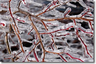
Freezing rain is a condition where precipitation which has fallen in the form of
water droplets reaches temperatures which are below freezing and freezes upon
coming into contact
with surface objects. The result of this precipitation is a glaze of ice which
can be damaging to plants and man-made structures. A severe onset of freezing
rain which results in a very thick glaze of ice is known as an ice storm.
Next Topic: Graupel
Current conditions powered by WeatherAPI.com


