Weather Alert in Michigan
Winter Weather Advisory issued February 8 at 9:04PM EST until February 10 at 1:00AM EST by NWS Marquette MI
AREAS AFFECTED: Iron; Dickinson; Menominee
DESCRIPTION: * WHAT...Mixed precipitation expected. Total snow accumulations up to one inch and ice accumulations up to one tenth of an inch. * WHERE...Dickinson, Iron, and Menominee Counties. * WHEN...From 3 PM Monday to midnight CST Monday Night. * IMPACTS...Plan on slippery road conditions. The hazardous conditions will impact the Monday evening commute. * ADDITIONAL DETAILS...Precipitation will start out as freezing rain before transitioning to wet snow late in the evening. Untreated surfaces and particularly secondary roads that are already snow packed could become very slippery.
INSTRUCTION: Slow down and use caution while traveling.
Want more detail? Get the Complete 7 Day and Night Detailed Forecast!
Current U.S. National Radar--Current
The Current National Weather Radar is shown below with a UTC Time (subtract 5 hours from UTC to get Eastern Time).

National Weather Forecast--Current
The Current National Weather Forecast and National Weather Map are shown below.

National Weather Forecast for Tomorrow
Tomorrow National Weather Forecast and Tomorrow National Weather Map are show below.

North America Water Vapor (Moisture)
This map shows recent moisture content over North America. Bright and colored areas show high moisture (ie, clouds); brown indicates very little moisture present; black indicates no moisture.

Weather Topic: What is Fog?
Home - Education - Cloud Types - Fog
 Next Topic: Fractus Clouds
Fog is technically a type of stratus cloud, which lies along the
ground and obscures visibility.
It is usually created when humidity in the air condenses into tiny water droplets.
Because of this, some places are more prone to foggy weather, such as regions
close to a body of water.
Fog is similar to mist; both are the appearance of water droplets suspended in
the air, but fog is the term applied to the condition when visibility is less than 1 km.
Next Topic: Fractus Clouds
Weather Topic: What is Freezing Rain?
Home - Education - Precipitation - Freezing Rain
 Next Topic: Graupel
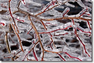
Freezing rain is a condition where precipitation which has fallen in the form of
water droplets reaches temperatures which are below freezing and freezes upon
coming into contact
with surface objects. The result of this precipitation is a glaze of ice which
can be damaging to plants and man-made structures. A severe onset of freezing
rain which results in a very thick glaze of ice is known as an ice storm.
Next Topic: Graupel
Current conditions powered by WeatherAPI.com


