Weather Alert in California
Hydrologic Outlook issued February 19 at 1:26PM PST by NWS Medford OR
AREAS AFFECTED: Siskiyou, CA; Coos, OR; Curry, OR; Josephine, OR
DESCRIPTION: ESFMFR A moderate atmospheric river will likely bring periods of moderate to heavy rainfall later this weekend into early next week. The first frontal system is forecast to arrive late Saturday night into Sunday with multiple waves of precipitation continuing Sunday night through Tuesday morning. Preliminary estimates are showing widespread amounts of 4 to 6 inches along the coast with locally 8 inches in the favored coast ranges of Curry County. Amounts of 3 to 5 inches are possible in the Mount Shasta region and also other favored areas of western Siskiyou County. Small streams and creeks are likely to rise rapidly during this event with nuisance flooding and ponding of water on roadways during periods of heavy rain. Significant rises on main stem rivers and flashier creeks are also expected. Given that rivers are still running fairly low for this time of year, river flooding potential is a bit lower than usual, but there is at least a low probability of some flooding, especially in the Coquille Basin. While the exact scenario for the heavy rainfall and potential flooding remains uncertain, we will continue to monitor the forecasts and update accordingly. Flood Watches may be issued by the National Weather Service if this situation worsens.
INSTRUCTION: N/A
Want more detail? Get the Complete 7 Day and Night Detailed Forecast!
Current U.S. National Radar--Current
The Current National Weather Radar is shown below with a UTC Time (subtract 5 hours from UTC to get Eastern Time).

National Weather Forecast--Current
The Current National Weather Forecast and National Weather Map are shown below.

National Weather Forecast for Tomorrow
Tomorrow National Weather Forecast and Tomorrow National Weather Map are show below.

North America Water Vapor (Moisture)
This map shows recent moisture content over North America. Bright and colored areas show high moisture (ie, clouds); brown indicates very little moisture present; black indicates no moisture.

Weather Topic: What is Fog?
Home - Education - Cloud Types - Fog
 Next Topic: Fractus Clouds
Fog is technically a type of stratus cloud, which lies along the
ground and obscures visibility.
It is usually created when humidity in the air condenses into tiny water droplets.
Because of this, some places are more prone to foggy weather, such as regions
close to a body of water.
Fog is similar to mist; both are the appearance of water droplets suspended in
the air, but fog is the term applied to the condition when visibility is less than 1 km.
Next Topic: Fractus Clouds
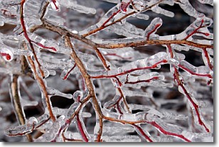
Weather Topic: What is Freezing Rain?
Home - Education - Precipitation - Freezing Rain
 Next Topic: Graupel
Freezing rain is a condition where precipitation which has fallen in the form of
water droplets reaches temperatures which are below freezing and freezes upon
coming into contact
with surface objects. The result of this precipitation is a glaze of ice which
can be damaging to plants and man-made structures. A severe onset of freezing
rain which results in a very thick glaze of ice is known as an ice storm.
Next Topic: Graupel
Current conditions powered by WeatherAPI.com


