Weather Alert in Hawaii
High Surf Advisory issued February 24 at 3:27PM HST until February 25 at 6:00AM HST by NWS Honolulu HI
AREAS AFFECTED: Maui Leeward West; Kohala; Molokai West; Lanai Windward
DESCRIPTION: ...HIGH SURF ADVISORY FOR NORTH AND EAST FACING SHORES OF NIIHAU KAUAI AND OAHU...NORTH AND WEST FACING SHORES OF MOLOKAI MAUI AND BIG ISLAND...NORTH FACING SHORES OF LANAI THROUGH EARLY WEDNESDAY MORNING... .A long period north-northeast (010-030 degrees) peaked early this morning, producing much larger than normal surf across some coastlines, especially across windward areas. The swell will gradually decline late this afternoon through Friday. * WHAT...Along west facing shores of the Big Island in the Kohala Districts, surf heights of 6 to 8 feet. Along west facing shores of Maui, surf heights of 10 to 15 feet, dropping to 8 to 12 feet. Along west facing shores of Molokai and north facing shores of Lanai, surf heights of 8 to 12 feet. * WHERE...West facing shores of Molokai, Maui, and Big Island and for north facing shores of Lanai. * WHEN...Until 6 AM HST Wednesday. * IMPACTS...Moderate. Strong breaking waves and strong currents will make swimming dangerous.
INSTRUCTION: Heed all advice from ocean safety officials. When in doubt, don't go out.
Want more detail? Get the Complete 7 Day and Night Detailed Forecast!
Current U.S. National Radar--Current
The Current National Weather Radar is shown below with a UTC Time (subtract 5 hours from UTC to get Eastern Time).

National Weather Forecast--Current
The Current National Weather Forecast and National Weather Map are shown below.

National Weather Forecast for Tomorrow
Tomorrow National Weather Forecast and Tomorrow National Weather Map are show below.

North America Water Vapor (Moisture)
This map shows recent moisture content over North America. Bright and colored areas show high moisture (ie, clouds); brown indicates very little moisture present; black indicates no moisture.

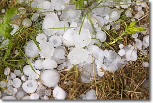
Weather Topic: What is Hail?
Home - Education - Precipitation - Hail
 Next Topic: Hole Punch Clouds
Hail is a form of precipitation which is recognized by large solid balls or
clumps of ice. Hail is created by thunderstorm clouds with strong updrafts of wind.
As the hailstones remain in the updraft, ice is deposited onto them until their
weight becomes heavy enough for them to fall to the earth's surface.
Hail storms can cause significant damage to crops, aircrafts, and man-made structures,
despite the fact that the duration is usually less than ten minutes.
Next Topic: Hole Punch Clouds
Weather Topic: What are Mammatus Clouds?
Home - Education - Cloud Types - Mammatus Clouds
 Next Topic: Nimbostratus Clouds
A mammatus cloud is a cloud with a unique feature which resembles
a web of pouches hanging along the base of the cloud.
In the United States, mammatus clouds tend to form in the warmer months, commonly
in the Midwest and eastern regions.
While they usually form at the bottom of a cumulonimbis cloud, they can also form
under altostratus, altocumulus, stratocumulus, and cirrus clouds. Mammatus clouds
warn that severe weather is close.
Next Topic: Nimbostratus Clouds
Current conditions powered by WeatherAPI.com


