Weather Alert in Hawaii
High Surf Advisory issued February 24 at 3:27PM HST until February 25 at 6:00AM HST by NWS Honolulu HI
AREAS AFFECTED: Niihau; Oahu North Shore; Olomana; Maui Windward West; Kauai North; Kauai East; Koolau Windward; Molokai Windward; Molokai North; Maui Central Valley North; Windward Haleakala; Big Island East; Big Island North
DESCRIPTION: ...HIGH SURF ADVISORY FOR NORTH AND EAST FACING SHORES OF NIIHAU KAUAI AND OAHU...NORTH AND WEST FACING SHORES OF MOLOKAI MAUI AND BIG ISLAND...NORTH FACING SHORES OF LANAI THROUGH EARLY WEDNESDAY MORNING... .A long period north-northeast (010-030 degrees) peaked early this morning, producing much larger than normal surf across some coastlines, especially across windward areas. The swell will gradually decline late this afternoon through Friday. * WHAT...Along north facing shores, surf heights of 18 to 24 feet this evening, dropping to 15 to 20 feet. Along east facing shores, surf heights of 12 to 16 feet this evening, dropping to 10 to 14 feet. * WHERE...North and east facing shores of Niihau, Kauai, Oahu, Molokai, Maui, and Big Island. * WHEN...Until 6 AM HST Wednesday. * IMPACTS...Moderate. Strong breaking waves and strong currents will make swimming dangerous.
INSTRUCTION: Heed all advice from ocean safety officials. When in doubt, don't go out.
Want more detail? Get the Complete 7 Day and Night Detailed Forecast!
Current U.S. National Radar--Current
The Current National Weather Radar is shown below with a UTC Time (subtract 5 hours from UTC to get Eastern Time).

National Weather Forecast--Current
The Current National Weather Forecast and National Weather Map are shown below.

National Weather Forecast for Tomorrow
Tomorrow National Weather Forecast and Tomorrow National Weather Map are show below.

North America Water Vapor (Moisture)
This map shows recent moisture content over North America. Bright and colored areas show high moisture (ie, clouds); brown indicates very little moisture present; black indicates no moisture.

Weather Topic: What is Rain?
Home - Education - Precipitation - Rain
 Next Topic: Shelf Clouds
Precipitation in the form of water droplets is called rain.
Rain generally has a tendency to fall with less intensity over a greater period
of time, and when rainfall is more severe it is usually less sustained.
Rain is the most common form of precipitation and happens with greater frequency
depending on the season and regional influences. Cities have been shown to have
an observable effect on rainfall, due to an effect called the urban heat island.
Compared to upwind, monthly rainfall between twenty and forty miles downwind of
cities is 30% greater.
Next Topic: Shelf Clouds
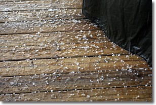
Weather Topic: What is Sleet?
Home - Education - Precipitation - Sleet
 Next Topic: Snow
Sleet is a form of precipitation in which small ice pellets are the primary
components. These ice pellets are smaller and more translucent than hailstones,
and harder than graupel. Sleet is caused by specific atmospheric conditions and
therefore typically doesn't last for extended periods of time.
The condition which leads to sleet formation requires a warmer body of air to be
wedged in between two sub-freezing bodies of air. When snow falls through a warmer
layer of air it melts, and as it falls through the next sub-freezing body of air
it freezes again, forming ice pellets known as sleet. In some cases, water
droplets don't have time to freeze before reaching the surface and the result is
freezing rain.
Next Topic: Snow
Current conditions powered by WeatherAPI.com


