Weather Alert in Nebraska
Dense Fog Advisory issued September 2 at 7:00AM CDT until September 2 at 10:00AM CDT by NWS Hastings NE
AREAS AFFECTED: Valley; Greeley; Nance; Sherman; Howard; Merrick; Polk; Dawson; York
DESCRIPTION: * WHAT...Visibility one-quarter mile or less in dense fog, mainly in limited areas. * WHERE...Greeley, Howard, Merrick, Nance, Sherman, Valley, Polk, York, and Dawson Counties. * WHEN...Until 10 AM CDT this morning. * IMPACTS...Low visibility could make driving conditions hazardous, including for the Tuesday morning commute. * ADDITIONAL DETAILS...Although at least light fog is possible within the Advisory area, the development of truly dense fog, reducing visibility to 1/4 mile or less, will likely be rather hit-and-miss in nature...impacting only limited areas. This will result in widely varying visibilities, including over short distances. Although most locations will probably not observe truly dense fog, the Advisory continues at this time.
INSTRUCTION: If driving, slow down, use your headlights, and leave plenty of distance ahead of you.
Want more detail? Get the Complete 7 Day and Night Detailed Forecast!
Current U.S. National Radar--Current
The Current National Weather Radar is shown below with a UTC Time (subtract 5 hours from UTC to get Eastern Time).

National Weather Forecast--Current
The Current National Weather Forecast and National Weather Map are shown below.

National Weather Forecast for Tomorrow
Tomorrow National Weather Forecast and Tomorrow National Weather Map are show below.

North America Water Vapor (Moisture)
This map shows recent moisture content over North America. Bright and colored areas show high moisture (ie, clouds); brown indicates very little moisture present; black indicates no moisture.

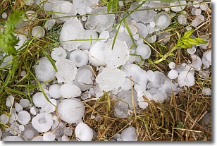
Weather Topic: What is Hail?
Home - Education - Precipitation - Hail
 Next Topic: Hole Punch Clouds
Hail is a form of precipitation which is recognized by large solid balls or
clumps of ice. Hail is created by thunderstorm clouds with strong updrafts of wind.
As the hailstones remain in the updraft, ice is deposited onto them until their
weight becomes heavy enough for them to fall to the earth's surface.
Hail storms can cause significant damage to crops, aircrafts, and man-made structures,
despite the fact that the duration is usually less than ten minutes.
Next Topic: Hole Punch Clouds
Weather Topic: What are Mammatus Clouds?
Home - Education - Cloud Types - Mammatus Clouds
 Next Topic: Nimbostratus Clouds
A mammatus cloud is a cloud with a unique feature which resembles
a web of pouches hanging along the base of the cloud.
In the United States, mammatus clouds tend to form in the warmer months, commonly
in the Midwest and eastern regions.
While they usually form at the bottom of a cumulonimbis cloud, they can also form
under altostratus, altocumulus, stratocumulus, and cirrus clouds. Mammatus clouds
warn that severe weather is close.
Next Topic: Nimbostratus Clouds
Current conditions powered by WeatherAPI.com


