Weather Alert in Alaska
Winter Storm Warning issued February 19 at 4:09AM AKST until February 20 at 9:00AM AKST by NWS Juneau AK
AREAS AFFECTED: City and Borough of Sitka
DESCRIPTION: ...ACCUMULATING SNOW ACROSS THE PANHANDLE TO END THE WEEK... .A front moving across the gulf and developing low across the northern coast will bring snow showers to the panhandle beginning late Wednesday night. With stable cold dry continental air in place ahead of this system, precipitation is expected to remain snow throughout the event with high snow ratios. The initial frontal wave will push eastward into the panhandle with the northeast gulf coast seeing showers late tonight and highest snow accumulations expected along the outer coast with orographic enhancement. For most areas, snow is expected to be light and fluffy in nature due to cold temperatures both aloft and down to the surface. * WHAT...Heavy snow expected. Total snow accumulations of 9 to 13 inches. * WHERE...City and Borough of Sitka. * WHEN...From 6 AM this morning to 9 AM AKST Friday. * IMPACTS...Travel will be very difficult. The hazardous conditions could impact the morning and evening commute. * ADDITIONAL DETAILS...Snow showers are expected to begin early Thursday morning and increase in intensity through the day as the initial frontal band pushes into the outer coast. A secondary surge of heavier showers is expected to impact the area soon afterwards as the surface low drops southward into the gulf.
INSTRUCTION: If you must travel, keep an extra flashlight, food, and water with you in case of an emergency. People are urged to prepare their property before the onset of winter weather. For the latest road conditions, where available, call 5 1 1 or visit 511.alaska.gov.
Want more detail? Get the Complete 7 Day and Night Detailed Forecast!
Current U.S. National Radar--Current
The Current National Weather Radar is shown below with a UTC Time (subtract 5 hours from UTC to get Eastern Time).

National Weather Forecast--Current
The Current National Weather Forecast and National Weather Map are shown below.

National Weather Forecast for Tomorrow
Tomorrow National Weather Forecast and Tomorrow National Weather Map are show below.

North America Water Vapor (Moisture)
This map shows recent moisture content over North America. Bright and colored areas show high moisture (ie, clouds); brown indicates very little moisture present; black indicates no moisture.

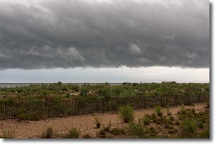
Weather Topic: What are Shelf Clouds?
Home - Education - Cloud Types - Shelf Clouds
 Next Topic: Sleet
A shelf cloud is similar to a wall cloud, but forms at the front
of a storm cloud, instead of at the rear, where wall clouds form.
A shelf cloud is caused by a series of events set into motion by the advancing
storm; first, cool air settles along the ground where precipitation has just fallen.
As the cool air is brought in, the warmer air is displaced, and rises above it,
because it is less dense. When the warmer air reaches the bottom of the storm cloud,
it begins to cool again, and the resulting condensation is a visible shelf cloud.
Next Topic: Sleet
Weather Topic: What is Snow?
Home - Education - Precipitation - Snow
 Next Topic: Stratocumulus Clouds
Snow is precipitation taking the form of ice crystals. Each ice crystal, or snowflake,
has unique characteristics, but all of them grow in a hexagonal structure.
Snowfall can last for sustained periods of time and result in significant buildup
of snow on the ground.
On the earth's surface, snow starts out light and powdery, but as it begins to melt
it tends to become more granular, producing small bits of ice which have the consistency of
sand. After several cycles of melting and freezing, snow can become very dense
and ice-like, commonly known as snow pack.
Next Topic: Stratocumulus Clouds
Current conditions powered by WeatherAPI.com


