Weather Alert in Iowa
Winter Weather Advisory issued February 19 at 2:49AM CST until February 20 at 6:00AM CST by NWS Quad Cities IA IL
AREAS AFFECTED: Buchanan; Delaware; Dubuque; Benton; Linn; Jones
DESCRIPTION: * WHAT...Snow, blowing snow and some drifting is expected. Total snow accumulations between 3 and 5 inches. Localized totals up to 6 inches are possible. Winds gusting as high as 35 mph. * WHERE...Portions of east central and northeast Iowa. * WHEN...From 6 PM this evening to 6 AM CST Friday. * IMPACTS...Plan on slippery road conditions, blowing snow and minor drifting of snow. * ADDITIONAL DETAILS...There remains the potential for higher snowfall totals in this advisory. Uncertainty in where the snow band may set up remains and a last minute upgrade to a Winter Storm Warning cannot be ruled out. Snow will initially melt on area roadways before accumulating. The highest snowfall totals will be on grassy surfaces.
INSTRUCTION: Slow down and use caution while traveling. the latest road conditions are available at 511ia.org or by calling 511.
Want more detail? Get the Complete 7 Day and Night Detailed Forecast!
Current U.S. National Radar--Current
The Current National Weather Radar is shown below with a UTC Time (subtract 5 hours from UTC to get Eastern Time).

National Weather Forecast--Current
The Current National Weather Forecast and National Weather Map are shown below.

National Weather Forecast for Tomorrow
Tomorrow National Weather Forecast and Tomorrow National Weather Map are show below.

North America Water Vapor (Moisture)
This map shows recent moisture content over North America. Bright and colored areas show high moisture (ie, clouds); brown indicates very little moisture present; black indicates no moisture.

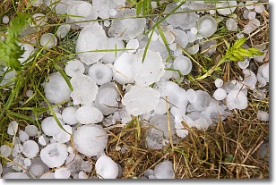
Weather Topic: What is Hail?
Home - Education - Precipitation - Hail
 Next Topic: Hole Punch Clouds
Hail is a form of precipitation which is recognized by large solid balls or
clumps of ice. Hail is created by thunderstorm clouds with strong updrafts of wind.
As the hailstones remain in the updraft, ice is deposited onto them until their
weight becomes heavy enough for them to fall to the earth's surface.
Hail storms can cause significant damage to crops, aircrafts, and man-made structures,
despite the fact that the duration is usually less than ten minutes.
Next Topic: Hole Punch Clouds
Weather Topic: What are Mammatus Clouds?
Home - Education - Cloud Types - Mammatus Clouds
 Next Topic: Nimbostratus Clouds
A mammatus cloud is a cloud with a unique feature which resembles
a web of pouches hanging along the base of the cloud.
In the United States, mammatus clouds tend to form in the warmer months, commonly
in the Midwest and eastern regions.
While they usually form at the bottom of a cumulonimbis cloud, they can also form
under altostratus, altocumulus, stratocumulus, and cirrus clouds. Mammatus clouds
warn that severe weather is close.
Next Topic: Nimbostratus Clouds
Current conditions powered by WeatherAPI.com


