Weather Alert in California
Severe Thunderstorm Warning issued February 17 at 6:13PM PST until February 17 at 7:45PM PST by NWS Los Angeles/Oxnard CA
AREAS AFFECTED: San Luis Obispo, CA
DESCRIPTION: SVRLOX The National Weather Service in OXNARD has issued a * Severe Thunderstorm Warning for... Central San Luis Obispo County in southwestern California... * Until 745 PM PST. * At 612 PM PST, severe thunderstorms were located along a line extending from near Paso Robles to 64 miles southwest of Morro Bay, moving east at 30 mph. HAZARD...60 mph wind gusts. Brief weak tornado possible. SOURCE...Radar indicated. IMPACT...Expect damage to roofs, siding, and trees. * Locations impacted include... Santa Maria... San Luis Obispo... Paso Robles... Morro Bay... Pismo Beach... Atascadero... Arroyo Grande... Nipomo... Grover Beach... Oceano... Black Mountain... Santa Margarita... Shandon... Avila Beach... Diablo Canyon... Cayucos... Baywood-Los Osos... Templeton... Highway 101 over Cuesta Grade... and Shell Beach.
INSTRUCTION: Remain alert for a possible tornado! Tornadoes can develop quickly from severe thunderstorms. If you spot a tornado go at once into the basement or small central room in a sturdy structure. For your protection move to an interior room on the lowest floor of a building.
Want more detail? Get the Complete 7 Day and Night Detailed Forecast!
Current U.S. National Radar--Current
The Current National Weather Radar is shown below with a UTC Time (subtract 5 hours from UTC to get Eastern Time).

National Weather Forecast--Current
The Current National Weather Forecast and National Weather Map are shown below.

National Weather Forecast for Tomorrow
Tomorrow National Weather Forecast and Tomorrow National Weather Map are show below.

North America Water Vapor (Moisture)
This map shows recent moisture content over North America. Bright and colored areas show high moisture (ie, clouds); brown indicates very little moisture present; black indicates no moisture.

Weather Topic: What is Freezing Rain?
Home - Education - Precipitation - Freezing Rain
 Next Topic: Graupel
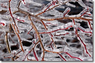
Freezing rain is a condition where precipitation which has fallen in the form of
water droplets reaches temperatures which are below freezing and freezes upon
coming into contact
with surface objects. The result of this precipitation is a glaze of ice which
can be damaging to plants and man-made structures. A severe onset of freezing
rain which results in a very thick glaze of ice is known as an ice storm.
Next Topic: Graupel
Weather Topic: What is Hail?
Home - Education - Precipitation - Hail
 Next Topic: Hole Punch Clouds
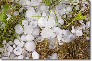
Hail is a form of precipitation which is recognized by large solid balls or
clumps of ice. Hail is created by thunderstorm clouds with strong updrafts of wind.
As the hailstones remain in the updraft, ice is deposited onto them until their
weight becomes heavy enough for them to fall to the earth's surface.
Hail storms can cause significant damage to crops, aircrafts, and man-made structures,
despite the fact that the duration is usually less than ten minutes.
Next Topic: Hole Punch Clouds
Current conditions powered by WeatherAPI.com


