Weather Alert in Minnesota
Winter Storm Watch issued February 15 at 2:32PM CST until February 19 at 12:00PM CST by NWS Duluth MN
AREAS AFFECTED: Koochiching; North St. Louis; Northern Cook/Northern Lake; North Itasca; Central St. Louis; North Cass; South Itasca; Northern Aitkin; Carlton/South St. Louis
DESCRIPTION: * WHAT...Heavy snow, patchy blowing snow, and mixed precipitation possible. There is a 50 to 90 percent chance for total snow accumulations in excess of 6 inches, highest for the higher terrain of the North Shore. There is also a 20 to 70 percent chance for at least a glaze of ice accumulations. Winds could gust as high as 35 mph. * WHERE...Northern Aitkin, Koochiching, North Cass, Itasca, Carlton, St. Louis, and Northern Cook and Lake Counties. This includes the Tribal Lands of the Fond du Lac Band, the Mille Lacs Band, Big Sandy Lake area and the Bois Forte Band, Nett Lake, Deer Creek and, Lake Vermilion areas. Other locations including Voyageurs National Park. The entire Boundary Waters is also included. * WHEN...From Tuesday evening through Thursday morning. * IMPACTS...Travel could be very difficult. The hazardous conditions could impact the Tuesday evening, Wednesday, and Thursday morning commutes. * ADDITIONAL DETAILS...Periods of gusty winds and visibility of less than one quarter mile are possible in the Winter Storm Watch area. The best potential for a wintry mix will be along and south of the Iron Range Tuesday evening into Wednesday morning.
INSTRUCTION: Monitor the latest forecasts for updates on this situation.
Want more detail? Get the Complete 7 Day and Night Detailed Forecast!
Current U.S. National Radar--Current
The Current National Weather Radar is shown below with a UTC Time (subtract 5 hours from UTC to get Eastern Time).

National Weather Forecast--Current
The Current National Weather Forecast and National Weather Map are shown below.

National Weather Forecast for Tomorrow
Tomorrow National Weather Forecast and Tomorrow National Weather Map are show below.

North America Water Vapor (Moisture)
This map shows recent moisture content over North America. Bright and colored areas show high moisture (ie, clouds); brown indicates very little moisture present; black indicates no moisture.

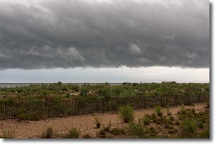
Weather Topic: What are Shelf Clouds?
Home - Education - Cloud Types - Shelf Clouds
 Next Topic: Sleet
A shelf cloud is similar to a wall cloud, but forms at the front
of a storm cloud, instead of at the rear, where wall clouds form.
A shelf cloud is caused by a series of events set into motion by the advancing
storm; first, cool air settles along the ground where precipitation has just fallen.
As the cool air is brought in, the warmer air is displaced, and rises above it,
because it is less dense. When the warmer air reaches the bottom of the storm cloud,
it begins to cool again, and the resulting condensation is a visible shelf cloud.
Next Topic: Sleet
Weather Topic: What is Snow?
Home - Education - Precipitation - Snow
 Next Topic: Stratocumulus Clouds
Snow is precipitation taking the form of ice crystals. Each ice crystal, or snowflake,
has unique characteristics, but all of them grow in a hexagonal structure.
Snowfall can last for sustained periods of time and result in significant buildup
of snow on the ground.
On the earth's surface, snow starts out light and powdery, but as it begins to melt
it tends to become more granular, producing small bits of ice which have the consistency of
sand. After several cycles of melting and freezing, snow can become very dense
and ice-like, commonly known as snow pack.
Next Topic: Stratocumulus Clouds
Current conditions powered by WeatherAPI.com


